File:Bucknall & Northwood Station (Disused) (geograph 6486867).jpg
Size of this preview: 800 × 533 pixels. Other resolutions: 320 × 213 pixels | 640 × 427 pixels | 1,024 × 682 pixels | 1,280 × 853 pixels | 2,000 × 1,333 pixels.
Original file (2,000 × 1,333 pixels, file size: 3.36 MB, MIME type: image/jpeg)
Captions
Captions
Add a one-line explanation of what this file represents
Summary
edit_(geograph_6486867).jpg&action=edit§ion=1)
| Description |
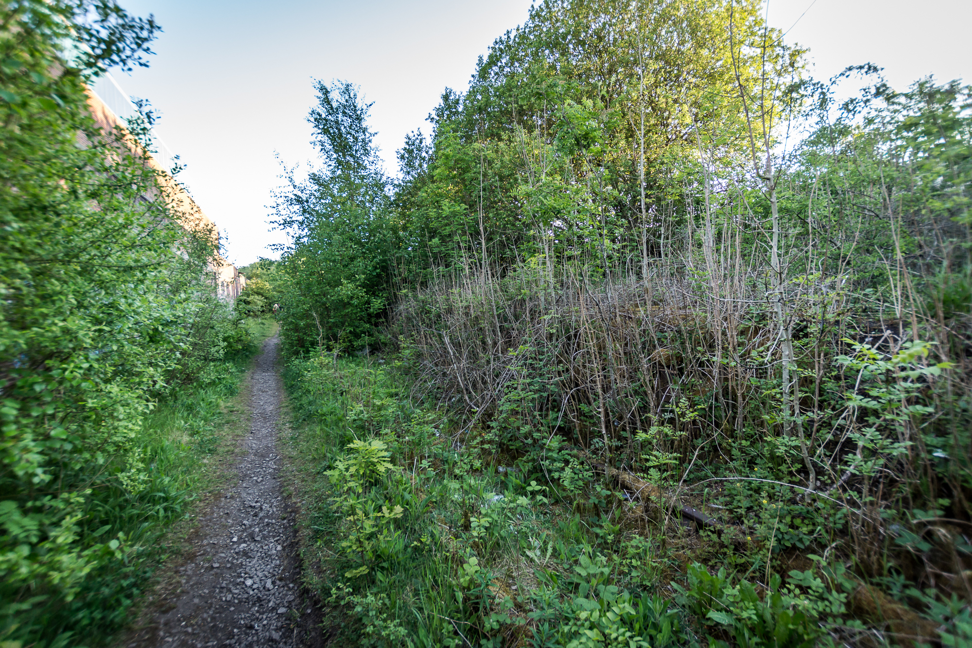
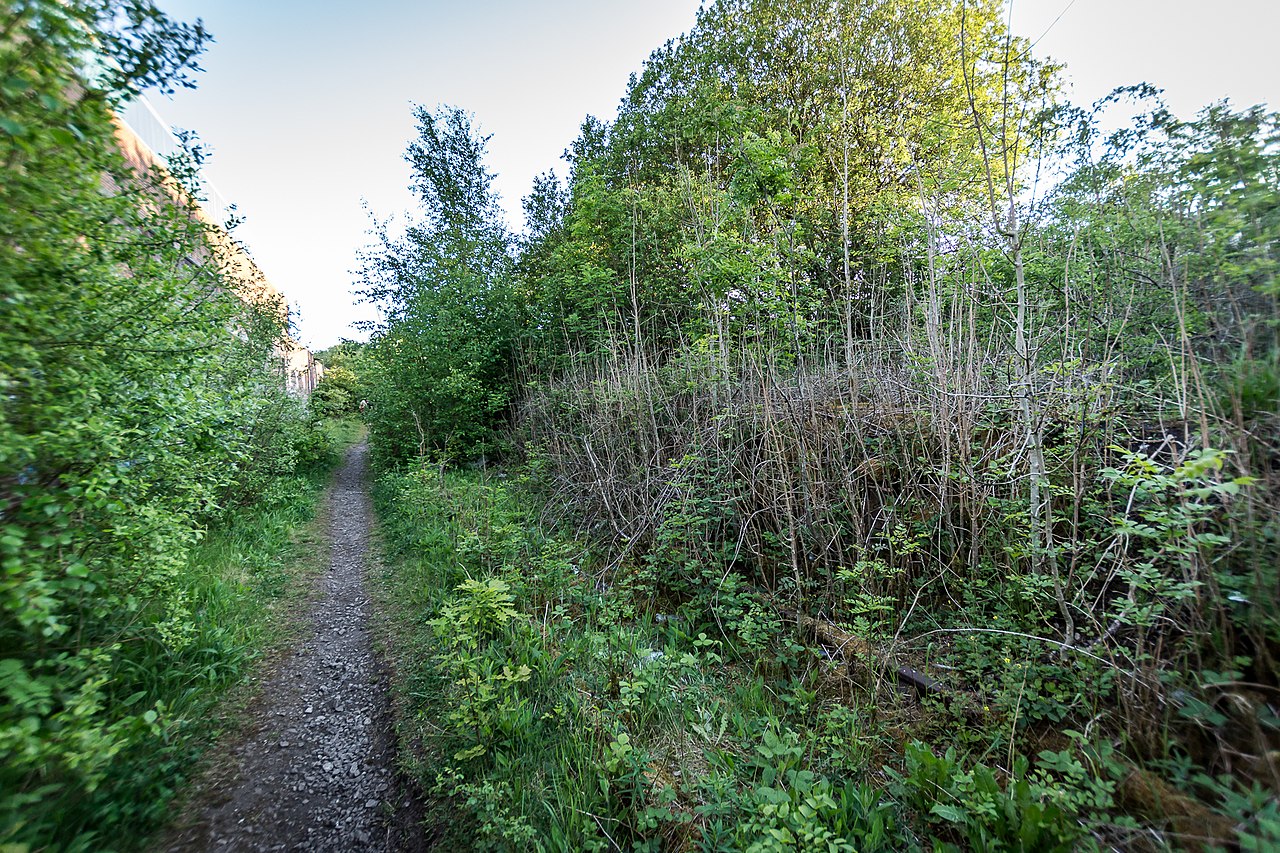
English: Bucknall & Northwood Station (Disused) Bucknall and Northwood railway station was opened by the North Staffordshire Railway in 1864 to serve the Bucknall area of Stoke-on-Trent. Situated on the company's Biddulph Valley line, the station was served by passenger trains between Stoke and Congleton on the Biddulph line and by trains between Stoke and Leek on the Stoke-Leek line. Passenger services on the Biddulph line ceased in 1927, but services on the Leek line continued until May 1956. After this date the station was still used for special and excursion trains until complete closure in 1962. The track is still in place but very overgrown. |
| Date | |
| Source | From geograph.org.uk |
| Author | Brian Deegan |
| Permission (Reusing this file) |
Creative Commons Attribution Share-alike license 2.0 |
| Attribution (required by the license) | Brian Deegan / Bucknall & Northwood Station (Disused) / |
| Camera location | | View this and other nearby images on: OpenStreetMap |
|---|
_(geograph_6486867).jpg¶ms=053.022811_N_-002.155452_E_globe:Earth_type:camera_source:geograph-osgb36(SJ8967047291)_heading:202.00&language=en)
| Object location | | View this and other nearby images on: OpenStreetMap |
|---|
_(geograph_6486867).jpg¶ms=053.022620_N_-002.155600_E_globe:Earth_class:object_type:object_source:geograph-osgb36(SJ89664727)_heading:202.00&language=en)
Licensing
edit_(geograph_6486867).jpg&action=edit§ion=2)

|
This image was taken from the Geograph project collection. See this photograph's page on the Geograph website for the photographer's contact details. The copyright on this image is owned by Brian Deegan and is licensed for reuse under the Creative Commons Attribution-ShareAlike 2.0 license.
|
This file is licensed under the Creative Commons Attribution-Share Alike 2.0 Generic license.
Attribution: Brian Deegan
- You are free:
- to share – to copy, distribute and transmit the work
- to remix – to adapt the work
- Under the following conditions:
- attribution – You must give appropriate credit, provide a link to the license, and indicate if changes were made. You may do so in any reasonable manner, but not in any way that suggests the licensor endorses you or your use.
- share alike – If you remix, transform, or build upon the material, you must distribute your contributions under the same or compatible license as the original.
File history
Click on a date/time to view the file as it appeared at that time.
| Date/Time | Thumbnail | Dimensions | User | Comment | |
|---|---|---|---|---|---|
| current | 21:21, 4 November 2020 | | 2,000 × 1,333 (3.36 MB) | Lamberhurst (talk | contribs) | Transferred from geograph.co.uk using [https://tools.wmflabs.org/geograph2commons/ geograph2commons] |
You cannot overwrite this file.
File usage on Commons
The following page uses this file:
_(geograph_6486867).jpg&oldid=836222723)