File:Buehler Karte.jpg

Size of this preview: 436 × 600 pixels. Other resolutions: 174 × 240 pixels | 349 × 480 pixels | 558 × 768 pixels | 744 × 1,024 pixels | 1,892 × 2,603 pixels.
Original file (1,892 × 2,603 pixels, file size: 4.29 MB, MIME type: image/jpeg)
Captions
Captions
Add a one-line explanation of what this file represents
Summary
edit
| Description |
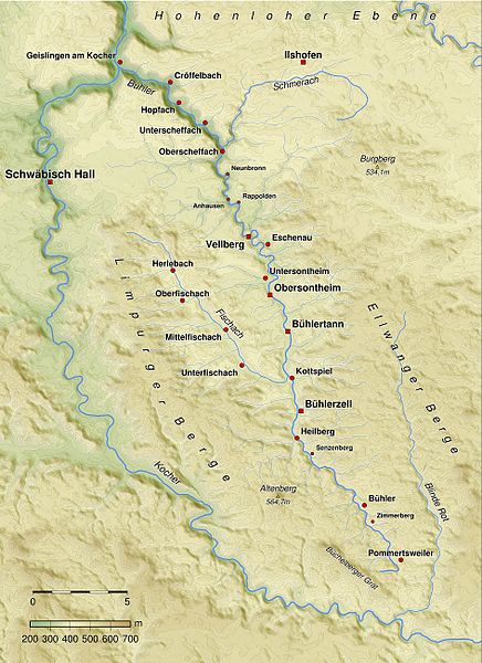
Deutsch: Karte des Verlaufs der Bühler und des überwiegenden Teils der in sie mündenden Bäche. English: Map of the river Bühler including most of its tributaries |
| Date |
7 March 2009 (original upload date) |
| Source | Aus eigener Herstellung unter Verwendung von SRTM-Daten, Qgis, Generic Mapping Tools. |
| Author | BerndH |
Licensing
edit
BerndH at the German-language Wikipedia, the copyright holder of this work, hereby publishes it under the following license:

|
Permission is granted to copy, distribute and/or modify this document under the terms of the GNU Free Documentation License, Version 1.2 or any later version published by the Free Software Foundation; with no Invariant Sections, no Front-Cover Texts, and no Back-Cover Texts. A copy of the license is included in the section entitled GNU Free Documentation License. |
| This file is licensed under the Creative Commons Attribution-Share Alike 3.0 Unported license. | ||
| Attribution: BerndH | ||
| ||
| This licensing tag was added to this file as part of the GFDL licensing update. |
Original upload log
edit
Transferred from de.wikipedia to Commons by Rosenzweig using CommonsHelper.
The original description page was here. All following user names refer to de.wikipedia.
- 2009-03-07 10:02 BerndH 1892×2603× (3402227 bytes) {{Information |Beschreibung = Karte des Verlaufs der Bühler und dem überwiegenden Teil der in sie mündenden Bäche. |Quelle = Aus eigener Herstellung unter Verwendung von SRTM-Daten, Qgis, Generic Mapping Tools. |Urheber = [[Benutzer:BerndH|BerndH]] |D
File history
Click on a date/time to view the file as it appeared at that time.
| Date/Time | Thumbnail | Dimensions | User | Comment | |
|---|---|---|---|---|---|
| current | 16:01, 16 July 2010 | | 1,892 × 2,603 (4.29 MB) | BerndH (talk | contribs) | update |
| 19:43, 8 March 2009 |  | 1,892 × 2,603 (3.24 MB) | File Upload Bot (Magnus Manske) (talk | contribs) | {{BotMoveToCommons|de.wikipedia|year={{subst:CURRENTYEAR}}|month={{subst:CURRENTMONTHNAME}}|day={{subst:CURRENTDAY}}}} {{Information |Description={{de|Karte des Verlaufs der Bühler und dem überwiegenden Teil der in sie mündenden Bäche.}} |Sou |
You cannot overwrite this file.
File usage on Commons
The following page uses this file:
File usage on other wikis
The following other wikis use this file:
- Usage on de.wikipedia.org
- Usage on ru.wikipedia.org
- Usage on www.wikidata.org