File:Bulgaria-geographic map-bg.svg

Size of this PNG preview of this SVG file: 800 × 529 pixels. Other resolutions: 320 × 212 pixels | 640 × 423 pixels | 1,024 × 677 pixels | 1,280 × 846 pixels | 2,560 × 1,693 pixels | 2,483 × 1,642 pixels.
Original file (SVG file, nominally 2,483 × 1,642 pixels, file size: 5.23 MB)
Captions
Captions
Add a one-line explanation of what this file represents
Summary edit
| Description |
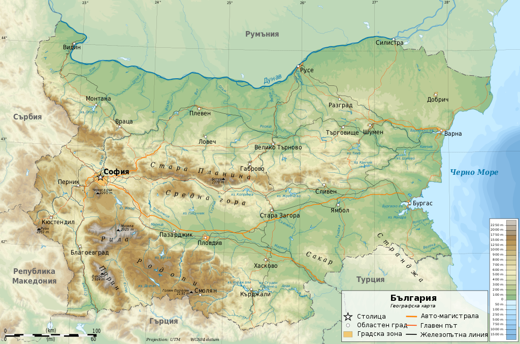
English: Geographic map of Bulgaria (in Bulgarian)
Български: Географска карта на България (на български)
UTM projection, WGS84 datum Geographic limits of the map:
|
| Date | |
| Source |
Own work Sources of data:
|
| Author | Ikonact |
| Other versions |
|


.svg)


|
This SVG file contains embedded text that can be translated into your language, using any capable SVG editor, text editor or the SVG Translate tool. For more information see: About translating SVG files. |
Licensing edit
I, the copyright holder of this work, hereby publish it under the following licenses:
This file is licensed under the Creative Commons Attribution-Share Alike 3.0 Unported license.
- You are free:
- to share – to copy, distribute and transmit the work
- to remix – to adapt the work
- Under the following conditions:
- attribution – You must give appropriate credit, provide a link to the license, and indicate if changes were made. You may do so in any reasonable manner, but not in any way that suggests the licensor endorses you or your use.
- share alike – If you remix, transform, or build upon the material, you must distribute your contributions under the same or compatible license as the original.

|
Permission is granted to copy, distribute and/or modify this document under the terms of the GNU Free Documentation License, Version 1.2 or any later version published by the Free Software Foundation; with no Invariant Sections, no Front-Cover Texts, and no Back-Cover Texts. A copy of the license is included in the section entitled GNU Free Documentation License. |
You may select the license of your choice.
File history
Click on a date/time to view the file as it appeared at that time.
| Date/Time | Thumbnail | Dimensions | User | Comment | |
|---|---|---|---|---|---|
| current | 18:51, 24 February 2013 | | 2,483 × 1,642 (5.23 MB) | Ikonact (talk | contribs) | more information |
| 23:48, 10 January 2013 |  | 2,483 × 1,642 (5.21 MB) | Ikonact (talk | contribs) | few more names added, font corrections, scale corraction | |
| 14:54, 2 December 2012 |  | 2,483 × 1,642 (5.28 MB) | Ikonact (talk | contribs) | improvements | |
| 23:04, 19 November 2012 |  | 2,483 × 1,642 (5.32 MB) | Ikonact (talk | contribs) | Names added, avoid text on path issue | |
| 23:28, 17 November 2012 |  | 2,483 × 1,642 (5.32 MB) | Ikonact (talk | contribs) | {{Information |Description ={{en|1=Geographic map of Bulgaria (in Bulgarian)}} {{bg|1=Географска карта на България (на български)}} UTM projection, WGS84 datum Geographic... |
You cannot overwrite this file.
File usage on Commons
The following 3 pages use this file:
File usage on other wikis
The following other wikis use this file:
- Usage on bg.wikipedia.org
- Usage on hyw.wikipedia.org