File:Bulletin 798 Plate12A View across Weiser Valley.jpg
Bulletin_798_Plate12A_View_across_Weiser_Valley.jpg (604 × 363 pixels, file size: 64 KB, MIME type: image/jpeg)
File information
Structured data
Captions
Captions
Add a one-line explanation of what this file represents
Summary edit
| DescriptionBulletin 798 Plate12A View across Weiser Valley.jpg |
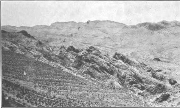
English: Original caption: View southwest across Weiser Valley. a, Kaibab limestone on west side of Weiser Ridge; b, gypsiferous shale at top of Supai formation; c, sandstone in Supai formation; d, Moenkopi formation; e, Chinle formation and Shinarump conglomerate; f, Moenkopi formation; g, Kaibab limestone. All beds dip west in overturned position. Weiser Valley fault between c and d. Text from the volume referring to the plate: Overturned fold in Weiser Ridge will be referred to as the Weiser anticline, and its broken continuation to the south as the Weiser thrust. The later normal fault, displacing the western limb of the anticline, will be called the Weiser Valley fault. West of this fault the formations have a synclinal structure, the Kaibab limestone turning up sharply in California Ridge, a close duplicate of Weiser Ridge. On its western flank the full thickness of the Supai formation lies in an inverted position, and a low, discontinuous ridge is made by upturned beds of Callville limestone. At several points these Pennsylvanian strata have been turned through an angle of 160° and now dip at a low angle away from the younger formations. This extreme overturning, which was accompanied by considerable crumpling, suggests that these beds were overridden by a thrust. The alternate assumption is an essentially recumbent anticline, the upper part of which has been removed by erosion. Whether the structure is that of a thrust or a fold, probably its continuation to the west has been concealed by displacement on a north-south fault paralleling the west border of the range. As no part of such a fault was seen, it is not represented on the geologic map. |
| Date | |
| Source | U.S. Geological Survey Bulletin 798, Geology of the Muddy Mountains, Nevada, with a section through the Virgin Range to the Grand Wash Cliffs, Arizona. By Chester R. Longwell. 1928. U.S. Government Printing Office, 152 p. ill., col. map (fold.); 23 cm. web version |
| Author | USGS |
Licensing edit
| Public domainPublic domainfalsefalse |
This work is in the public domain in the United States because it is a work prepared by an officer or employee of the United States Government as part of that person’s official duties under the terms of Title 17, Chapter 1, Section 105 of the US Code.
Note: This only applies to original works of the Federal Government and not to the work of any individual U.S. state, territory, commonwealth, county, municipality, or any other subdivision. This template also does not apply to postage stamp designs published by the United States Postal Service since 1978. (See § 313.6(C)(1) of Compendium of U.S. Copyright Office Practices). It also does not apply to certain US coins; see The US Mint Terms of Use.
|
 | |
| This file has been identified as being free of known restrictions under copyright law, including all related and neighboring rights. | ||
https://creativecommons.org/publicdomain/mark/1.0/PDMCreative Commons Public Domain Mark 1.0falsefalse
File history
Click on a date/time to view the file as it appeared at that time.
| Date/Time | Thumbnail | Dimensions | User | Comment | |
|---|---|---|---|---|---|
| current | 03:06, 27 July 2017 |  | 604 × 363 (64 KB) | Jstuby (talk | contribs) | User created page with UploadWizard |
You cannot overwrite this file.
File usage on Commons
There are no pages that use this file.
