File:Burg Hohenzollern, Bisingen-Zimmern.jpg

Size of this preview: 800 × 530 pixels. Other resolutions: 320 × 212 pixels | 640 × 424 pixels | 1,024 × 678 pixels | 1,280 × 848 pixels | 2,560 × 1,696 pixels | 4,928 × 3,264 pixels.
Original file (4,928 × 3,264 pixels, file size: 7.38 MB, MIME type: image/jpeg)
Captions
Captions
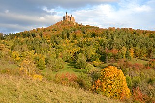
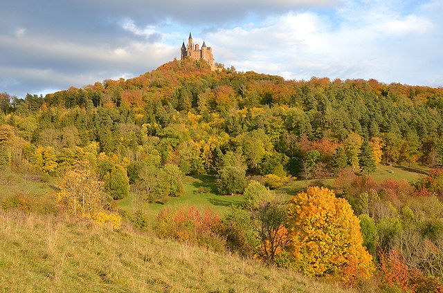
Hohenzollern Castle, Bisingen-Zimmern
Summary edit
| Description |
Deutsch: FFH-Gebiet Gebiete zwischen Bisingen, Haigerloch und Rosenfeld, Geotop Zollernberg mit Burg Hohenzollern bei Bisingen-Zimmern, Blick vom und über das Naturschutzgebiet Zollerhalde, Landschaftsschutzgebiet Oberes Starzeltal und Zollerberg, Vogelschutzgebiet Südwestalb und Oberes Donautal, Naturraum Südwestliches Albvorland |
| Date | |
| Source | Own work |
| Author | Olga Ernst |
| Camera location | | View this and other nearby images on: OpenStreetMap |
|---|
Licensing edit
I, the copyright holder of this work, hereby publish it under the following license:
This file is licensed under the Creative Commons Attribution-Share Alike 4.0 International license.
- You are free:
- to share – to copy, distribute and transmit the work
- to remix – to adapt the work
- Under the following conditions:
- attribution – You must give appropriate credit, provide a link to the license, and indicate if changes were made. You may do so in any reasonable manner, but not in any way that suggests the licensor endorses you or your use.
- share alike – If you remix, transform, or build upon the material, you must distribute your contributions under the same or compatible license as the original.
File history
Click on a date/time to view the file as it appeared at that time.
| Date/Time | Thumbnail | Dimensions | User | Comment | |
|---|---|---|---|---|---|
| current | 19:40, 26 October 2021 | | 4,928 × 3,264 (7.38 MB) | Olga Ernst (talk | contribs) | Uploaded own work with UploadWizard |
You cannot overwrite this file.
File usage on Commons
The following page uses this file:
File usage on other wikis
The following other wikis use this file:
- Usage on de.wikipedia.org
- Usage on en.wikipedia.org
- Usage on www.wikidata.org