File:Burgstall Hagenhill.png
Size of this preview: 800 × 445 pixels. Other resolutions: 320 × 178 pixels | 850 × 473 pixels.
Original file (850 × 473 pixels, file size: 908 KB, MIME type: image/png)
Captions
Captions
Add a one-line explanation of what this file represents
Summary
edit
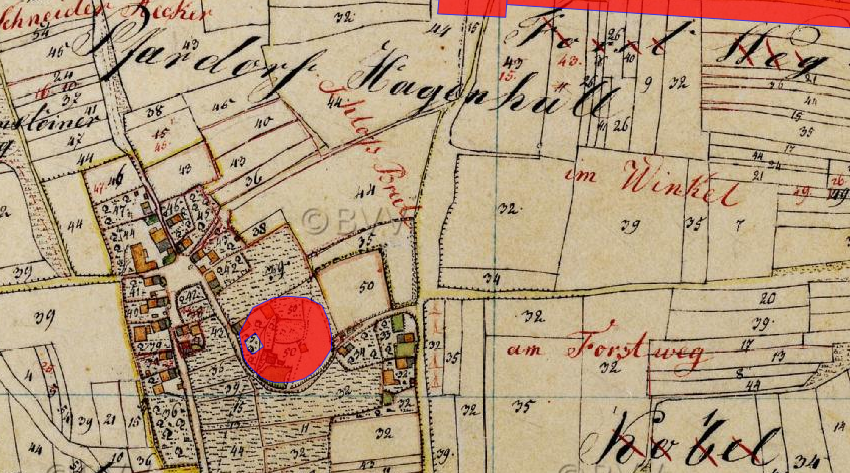
| Description | Lageplan von Burgstall Hagenhill auf dem Urkataster von Bayern | ||||
| Date | etwa 1830 | ||||
| Source | Geobasisdaten: Bayerische Vermessungsverwaltung | ||||
| Author | Königreich Bayern | ||||
| Permission (Reusing this file) |
|
||||
File history
Click on a date/time to view the file as it appeared at that time.
| Date/Time | Thumbnail | Dimensions | User | Comment | |
|---|---|---|---|---|---|
| current | 08:50, 16 October 2023 | | 850 × 473 (908 KB) | Luckyprof (talk | contribs) | {{Information |Description=Lageplan von Burgstall Hagenhill auf dem Urkataster von Bayern |Source= Geobasisdaten: Bayerische Vermessungsverwaltung |Date=etwa 1830 |Author=Königreich Bayern |Permission=CC BY-ND 3.0 DE |other_versions= }} Category:Hagenhill |
You cannot overwrite this file.
File usage on Commons
There are no pages that use this file.
File usage on other wikis
The following other wikis use this file:
- Usage on de.wikipedia.org