File:Burn of Corscarie - geograph.org.uk - 343685.jpg
No higher resolution available.
Burn_of_Corscarie_-_geograph.org.uk_-_343685.jpg (640 × 480 pixels, file size: 90 KB, MIME type: image/jpeg)
Captions
Captions
Add a one-line explanation of what this file represents
Summary
edit
| Description |
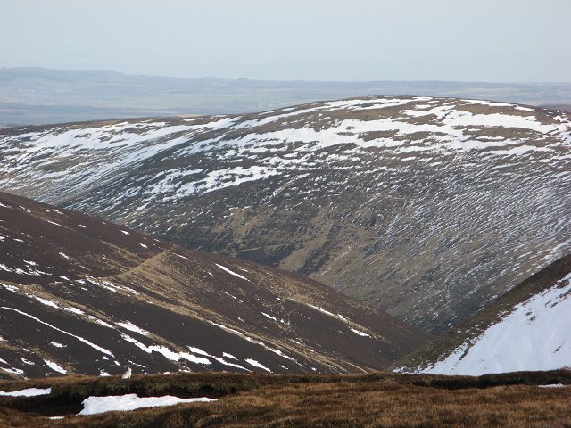
English: Burn of Corscarie The topography here in the eastern Mounth is defined by glens, not hills. The hills being remnants of high ground on a dissected plateau. This is a typical deep glen. Beyond Hill of Mondurran is the Highland Boundary Fault and lowland Strathmore. |
| Date | |
| Source | From geograph.org.uk |
| Author | Richard Webb |
| Attribution (required by the license) | Richard Webb / Burn of Corscarie / |
| Camera location | | View this and other nearby images on: OpenStreetMap |
|---|
_heading:112.00&language=en)
| Object location | | View this and other nearby images on: OpenStreetMap |
|---|
_heading:112.00&language=en)
Licensing
edit

|
This image was taken from the Geograph project collection. See this photograph's page on the Geograph website for the photographer's contact details. The copyright on this image is owned by Richard Webb and is licensed for reuse under the Creative Commons Attribution-ShareAlike 2.0 license.
|
This file is licensed under the Creative Commons Attribution-Share Alike 2.0 Generic license.
Attribution: Richard Webb
- You are free:
- to share – to copy, distribute and transmit the work
- to remix – to adapt the work
- Under the following conditions:
- attribution – You must give appropriate credit, provide a link to the license, and indicate if changes were made. You may do so in any reasonable manner, but not in any way that suggests the licensor endorses you or your use.
- share alike – If you remix, transform, or build upon the material, you must distribute your contributions under the same or compatible license as the original.
File history
Click on a date/time to view the file as it appeared at that time.
| Date/Time | Thumbnail | Dimensions | User | Comment | |
|---|---|---|---|---|---|
| current | 16:46, 2 January 2011 | | 640 × 480 (90 KB) | GeographBot (talk | contribs) | == {{int:filedesc}} == {{Information |description={{en|1=Burn of Corscarie The topography here in the eastern Mounth is defined by glens, not hills. The hills being remnants of high ground on a dissected plateau. This is a typical deep glen. Beyond Hill |
You cannot overwrite this file.
File usage on Commons
There are no pages that use this file.