File:Burned Area in Western Australia (MODIS 2020-02-16).jpg

Original file (2,647 × 2,086 pixels, file size: 887 KB, MIME type: image/jpeg)
Captions
Captions
Summary
edit.jpg&action=edit§ion=1)
| Description |
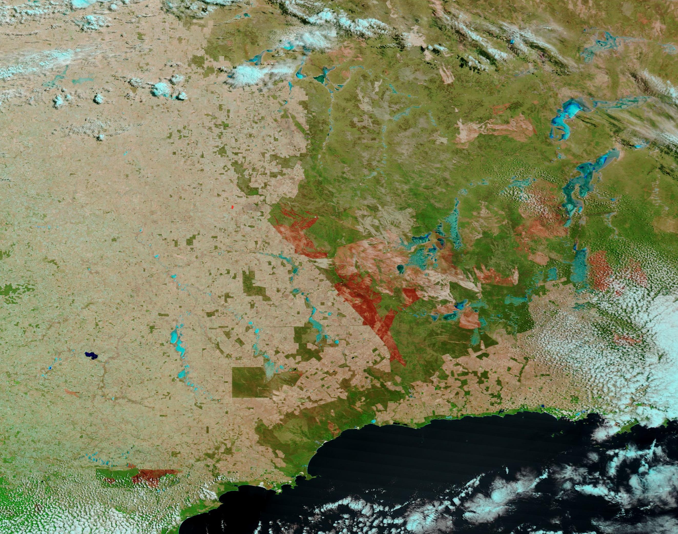
English: On February 6, 2020, a lightning strike ignited grass and bush in southern Western Australia. Thanks to dry, hot conditions, the spark spread rapidly to engulf 264,000 hectares (1,019 square miles) by February 16. On that day, the Western Australian government issued a Bushfire advice for parts of the Shires of Dundas, Kulin, Kondinin, Lake Grace, Narembeen and Yilgarn that stated that the fire was stationary and has been contained. Although there was no immediate danger, people near the fire area were cautioned to be extremely careful when driving through the advice area and watch for emergency service personnel and follow their directions. The Shire of Kondinin is handling this emergency.
The Moderate Resolution Imaging Spectroradiometer (MODIS) on board NASA’s Terra satellite acquired a false-color image of the area on February 13. This selection of bands (7,2,1) combines infrared and visible light to highlight burn scars, which appear brick red, and vegetation, which appears bright green. Deep water appears deep navy blue while more shallow water (lakes and river) appears bright blue. The appearance of cloud can range from white to electric blue, depending on the amount of ice the clouds contain—ice appears bright blue. This image shows a large area of brick red weaving in and out of a heavily vegetated area. This represents the burn scar – an area where vegetation has been burnt and, sometimes, land scorched, by fire. While this single image shows the effects of an impressively large fire, a comparison view between February 8, when the fire was actively raging, and this one helps associate the fire with the scar itself. Thanks to NASA’s Worldview app, that comparison can be found HERE The NASA Worldview app provides a satellite's perspective of the planet as it looks today and as it has in the past through daily satellite images. Worldview is part of NASA’s Earth Observing System Data and Information System. EOSDIS makes the agency's large repository of data accessible and freely available to the public. |
||
| Date | Taken on 13 February 2020 | ||
| Source |
Burned Area in Western Australia (direct link)
|
||
| Author | MODIS Land Rapid Response Team, NASA GSFC |
| This media is a product of the Terra mission Credit and attribution belongs to the mission team, if not already specified in the "author" row |
Licensing
edit.jpg&action=edit§ion=2)
| This file is in the public domain in the United States because it was solely created by NASA. NASA copyright policy states that "NASA material is not protected by copyright unless noted". (See Template:PD-USGov, NASA copyright policy page or JPL Image Use Policy.) | ||
 |
Warnings:
|
File history
Click on a date/time to view the file as it appeared at that time.
| Date/Time | Thumbnail | Dimensions | User | Comment | |
|---|---|---|---|---|---|
| current | 03:18, 17 February 2024 | | 2,647 × 2,086 (887 KB) | OptimusPrimeBot (talk | contribs) | #Spacemedia - Upload of http://modis.gsfc.nasa.gov/gallery/images/image02162020_250m.jpg via Commons:Spacemedia |
You cannot overwrite this file.
File usage on Commons
There are no pages that use this file.
.jpg&oldid=852708946)