File:Burstall Priory - geograph.org.uk - 322572.jpg
No higher resolution available.
Burstall_Priory_-_geograph.org.uk_-_322572.jpg (640 × 481 pixels, file size: 113 KB, MIME type: image/jpeg)
Captions
Captions
Add a one-line explanation of what this file represents
Summary edit
| Description |
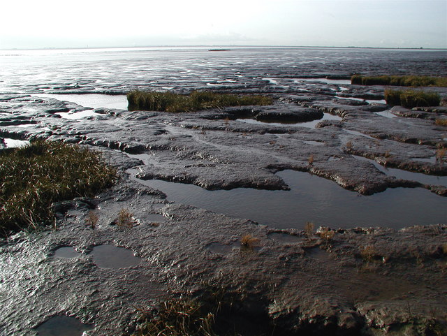
English: Burstall Priory, Skeffling, East Riding of Yorkshire, England. The River Humber, a hundred metres or so from the bank where the unpredictable saltmarsh gives way to a vast expanse of mud. Somewhere beneath all this is the site of Burstall Priory, founded by the Albermarle family of Normandy on land granted to them by William the Conqueror. The monks here were apparently subject to many hardships including the frequent seizure of their land during hostilities between England and France. The Priory was in ruins by 1720 and the last traces of it disappeared during floods in the 1900s. Bits of the property were salvaged over the centuries, including a stone doorway which is now in Easington Church and a tomb which was moved into the church at Welwick. Burstall Lane which once connected the priory with Skeffling village is now nothing more than a public footpath along a field drain but it does give a clue to the priory's former location. |
| Date | |
| Source | From geograph.org.uk |
| Author | Paul Glazzard |
| Permission (Reusing this file) |
Creative Commons Attribution Share-alike license 2.0 |
| Attribution (required by the license) | Paul Glazzard / Burstall Priory / |
| Camera location | | View this and other nearby images on: OpenStreetMap |
|---|
_heading:247.00&language=en)
| Object location | | View this and other nearby images on: OpenStreetMap |
|---|
_heading:247.00&language=en)
Licensing edit

|
This image was taken from the Geograph project collection. See this photograph's page on the Geograph website for the photographer's contact details. The copyright on this image is owned by Paul Glazzard and is licensed for reuse under the Creative Commons Attribution-ShareAlike 2.0 license.
|
This file is licensed under the Creative Commons Attribution-Share Alike 2.0 Generic license.
Attribution: Paul Glazzard
- You are free:
- to share – to copy, distribute and transmit the work
- to remix – to adapt the work
- Under the following conditions:
- attribution – You must give appropriate credit, provide a link to the license, and indicate if changes were made. You may do so in any reasonable manner, but not in any way that suggests the licensor endorses you or your use.
- share alike – If you remix, transform, or build upon the material, you must distribute your contributions under the same or compatible license as the original.
File history
Click on a date/time to view the file as it appeared at that time.
| Date/Time | Thumbnail | Dimensions | User | Comment | |
|---|---|---|---|---|---|
| current | 18:19, 30 December 2010 | | 640 × 481 (113 KB) | GeographBot (talk | contribs) | == {{int:filedesc}} == {{Information |description={{en|1=Burstall Priory The River Humber, a hundred metres or so from the bank where the unpredictable saltmarsh gives way to a vast expanse of mud. Somewhere beneath all this is the site of Burstall Priory |
You cannot overwrite this file.
File usage on Commons
There are no pages that use this file.
File usage on other wikis
The following other wikis use this file:
- Usage on en.wikipedia.org
- Usage on pt.wikipedia.org