File:Busanjin-map.png

Size of this preview: 550 × 599 pixels. Other resolutions: 220 × 240 pixels | 441 × 480 pixels | 705 × 768 pixels | 940 × 1,024 pixels | 2,500 × 2,723 pixels.
Original file (2,500 × 2,723 pixels, file size: 1.38 MB, MIME type: image/png)
Captions
Captions
Add a one-line explanation of what this file represents
Summary
edit
| Description |
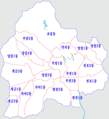
한국어: 분류:지도 그림 |
| Date | 25 November 2011 (original upload date) |
| Source | Transferred from ko.wikipedia to Commons. |
| Author | Gloyacks at Korean Wikipedia |
Licensing
edit
| |
This work has been released into the public domain by its author, Gloyacks, at the English Wikipedia project. This applies worldwide. In case this is not legally possible: |
Original upload log
edit
The original description page was here. All following user names refer to ko.wikipedia.
| Date/Time | Dimensions | User | Comment |
|---|---|---|---|
| 2015-01-03 04:36 | 1500×1609× (1187559 bytes) | Gloyacks | 행정구역명 재수정 |
| 2015-01-03 04:31 | 1500×1609× (816102 bytes) | Gloyacks | 행정구역명 수정 |
| 2014-02-15 03:32 | 1500×1609× (820426 bytes) | 안우석 | 가야제1동, 가야제3동의 통합 반영. 당감제1동과 당감제3동의 통합 반영. |
| 2012-07-25 17:11 | 1500×1609× (858071 bytes) | Asfreeas | Color Adjusted Adding Neighboring Area |
| 2011-11-25 12:30 | 1500×1609× (888976 bytes) | Gloyacks | {{파일 정보 |설명=부산 부산진구 행정구역도 |출처=자작 |날짜=2011년 11월 25일 |만든이=장길산 |저작권= |기타= }} |
File history
Click on a date/time to view the file as it appeared at that time.
| Date/Time | Thumbnail | Dimensions | User | Comment | |
|---|---|---|---|---|---|
| current | 02:45, 24 April 2017 | | 2,500 × 2,723 (1.38 MB) | Gloyacks (talk | contribs) | 경계선 및 지명수정 |
| 00:35, 16 December 2015 |  | 1,500 × 1,609 (1.13 MB) | Twotwo2019 (talk | contribs) | Transferred from ko.wikipedia |
You cannot overwrite this file.
File usage on Commons
There are no pages that use this file.
File usage on other wikis
The following other wikis use this file:
- Usage on ko.wikipedia.org