File:Butzenspitze 2547m Panorama.jpg

Size of this preview: 800 × 394 pixels. Other resolutions: 320 × 158 pixels | 640 × 315 pixels | 1,024 × 504 pixels | 1,280 × 630 pixels | 2,560 × 1,260 pixels | 4,729 × 2,328 pixels.
Original file (4,729 × 2,328 pixels, file size: 2.37 MB, MIME type: image/jpeg)
Captions
Captions
Add a one-line explanation of what this file represents
| Description |
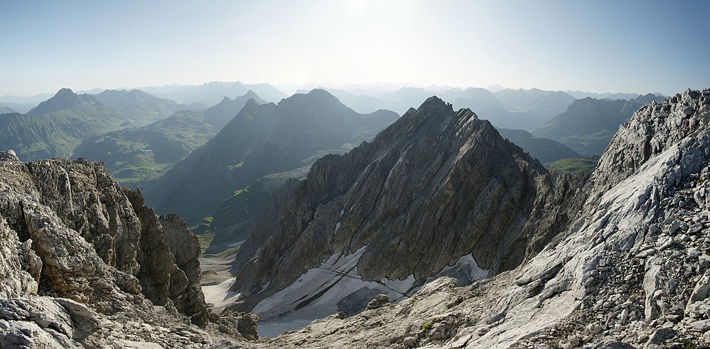
Deutsch: Panorama um 8°° Uhr früh mit mehreren Bilder. Vom Weimarer Steig, er führt zur Braunarlspitze 2649m, richtet sich der Blick über die Hochgletscher Alpe auf die 2.547m hohe Butzenspitze. Darunter sieht man im Dunst vor der Mohnenfluh 2.542m und der Juppenspitze 2.412m den gleichnamigen See, dem Butzensee. Dahinter im Warther Skigebiet die Karhorngruppe: Das Auenfelder Horn 2.292m, das Karhorn 2.416m und das Warther Horn 2.257m. Am Körbersee trennt der Hochtannbergpass das Lechquellengebirge von den Allgäuer Alpen. Das Bergmassiv am linken Bildrand ist der Große Widderstein 2.533m. |
| Date | |
| Source | Own work |
| Author | böhringer friedrich |
| Permission (Reusing this file) |
I, the copyright holder of this work, hereby publish it under the following license: This file is licensed under the Creative Commons Attribution-Share Alike 2.5 Generic license.
|
| Other versions |
 |
This Photo was taken by Böhringer Friedrich.
|
Feel free to use my photos, but please mention me as the author and if you want send me a message. or (rufre@lenz-nenning.at) |
| Camera location | | View this and other nearby images on: OpenStreetMap |
|---|
| Annotations | This image is annotated: View the annotations at Commons |
This image has been assessed using the Quality image guidelines and is considered a Quality image.
|
File history
Click on a date/time to view the file as it appeared at that time.
| Date/Time | Thumbnail | Dimensions | User | Comment | |
|---|---|---|---|---|---|
| current | 20:16, 24 August 2009 | | 4,729 × 2,328 (2.37 MB) | Böhringer (talk | contribs) | {{Information |Description= {{de| Panorama um 8°° Uhr früh mit mehreren Bilder. Vom Weimarer Steig, er führt zur Braunarlspitze 2649m, richtet sich der Blick über die Hochgletscher Alpe auf die 2.547m hohe Butzenspitze. Darunte |
You cannot overwrite this file.
File usage on Commons
The following 5 pages use this file:
File usage on other wikis
The following other wikis use this file:
- Usage on ceb.wikipedia.org
- Usage on de.wikipedia.org
- Usage on fr.wikipedia.org
- Usage on www.wikidata.org