File:Byzantine Constantinople regiones.svg

Size of this PNG preview of this SVG file: 662 × 600 pixels. Other resolutions: 265 × 240 pixels | 530 × 480 pixels | 848 × 768 pixels | 1,130 × 1,024 pixels | 2,261 × 2,048 pixels | 2,085 × 1,889 pixels.
Original file (SVG file, nominally 2,085 × 1,889 pixels, file size: 648 KB)
Captions
Captions
Add a one-line explanation of what this file represents
Summary
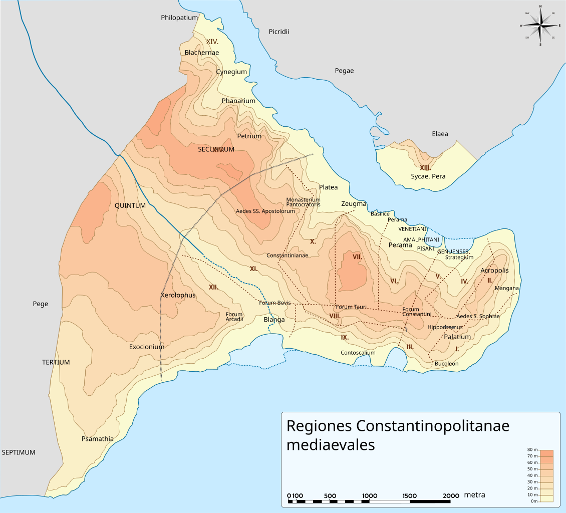
edit| Description | Map of Byzantine Constantinople showing numbered regions and major districts, named in Latin | ||
| Source | Own work based on File:Byzantine Constantinople.svg | ||
| Author | variant by Andrew Dalby of the work of Cplakidas | ||
| Permission (Reusing this file) |
I, the copyright holder of this work, hereby publish it under the following licenses: This file is licensed under the Creative Commons Attribution-Share Alike 3.0 Unported license.
You may select the license of your choice. |
||
| Other versions |
[] Full mapseditSVG:
PNG:
Numeric versionsedit
Regionsedit
Roadsedit
|


File history
Click on a date/time to view the file as it appeared at that time.
| Date/Time | Thumbnail | Dimensions | User | Comment | |
|---|---|---|---|---|---|
| current | 13:14, 6 October 2012 | | 2,085 × 1,889 (648 KB) | Andrew Dalby (talk | contribs) | minor additions. Added outer boundary. Revised location of XIV (cf. Janin, Constantinople byzantine, pp. 63-64) |
| 19:36, 5 October 2012 |  | 2,085 × 1,889 (643 KB) | Andrew Dalby (talk | contribs) | Tweaks | |
| 19:24, 5 October 2012 |  | 2,085 × 1,889 (634 KB) | Andrew Dalby (talk | contribs) | Lettering adjusted | |
| 19:15, 5 October 2012 |  | 2,085 × 1,889 (634 KB) | Andrew Dalby (talk | contribs) | {{Information |Description=Map of Byzantine Constantinople showing numbered regions and major districts, named in Latin |Source=Own work based on File:Byzantine Constantinople.svg |Date= |Author=variant by Andrew Dalby of the... |
You cannot overwrite this file.
File usage on Commons
The following 15 pages use this file:
- File:Byzantine Constantinople-de.svg
- File:Byzantine Constantinople-el.svg
- File:Byzantine Constantinople-en.png
- File:Byzantine Constantinople-en.svg
- File:Byzantine Constantinople-pt.svg
- File:Byzantine Constantinople-tr.png
- File:Byzantine Constantinople-tr.svg
- File:Byzantine Constantinople - ce.svg
- File:Byzantine Constantinople - ru.svg
- File:Byzantine Constantinople - uk.svg
- File:Byzantine Constantinople eu.png
- File:Byzantine Constantinople eu.svg
- File:Byzantine Constantinople regiones.svg
- File:Byzantine Constantinople viae.svg
- Template:Other versions/Byzantine Constantinople versions
File usage on other wikis
The following other wikis use this file:
- Usage on el.wikipedia.org
- Usage on en.wikipedia.org
- Usage on it.wikipedia.org
- Usage on la.wikipedia.org
- Sancta Sophia (Constantinopolis)
- Monasterium Pantocratoris (Constantinopolis)
- Porta Aurea
- Hippodromus (Constantinopolis)
- Formula:Regiones Constantinopolitanae
- Notitia urbis Constantinopolitanae
- Regiones Constantinopolitanae Theodosianae
- Regio I (Constantinopolis)
- Regio II (Constantinopolis)
- Regio III (Constantinopolis)
- Regio IV (Constantinopolis)
- Regio V (Constantinopolis)
- Regio VI (Constantinopolis)
- Regio VII (Constantinopolis)
- Regio VIII (Constantinopolis)
- Regio IX (Constantinopolis)
- Regio X (Constantinopolis)
- Regio XI (Constantinopolis)
- Regio XII (Constantinopolis)
- Regio XIII Sycaena
- Regio XIV (Constantinopolis)
- Formula:Monumenta Constantinopolis
- Formula:Media Constantinopolis
- Porta Aurea antiqua
- Augustaeum (Constantinopolis)
- Forum Bovis
- Forum Arcadii
- Amastrianum
- Forum Tauri
- Forum Constantini
- Columna Iustiniani
- Columna Constantini
- Porta Charsii
- Columna Theodosii
- Columna Arcadii
- Obeliscus Theodosii
- Obeliscus Constantini
- Palatium Hormisdae
- Philadelphium
- Bucoleon
- Palatium Magnum (Constantinopolis)
- Decaenneaccubita
- Chrysotriclinium
- Ecclesia Sanctae Mariae Blachernarum
- Monasterium Studii
View more global usage of this file.