File:CA Reclamation Districts Map.png

Size of this preview: 466 × 600 pixels. Other resolutions: 186 × 240 pixels | 548 × 705 pixels.
Original file (548 × 705 pixels, file size: 271 KB, MIME type: image/png)
Captions
Captions
Add a one-line explanation of what this file represents
Summary edit
| Description |
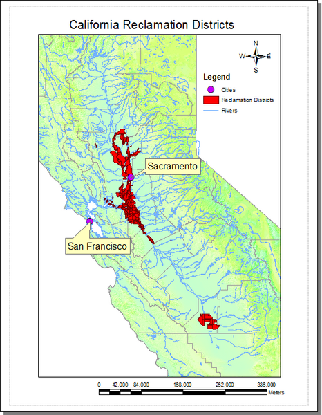
English: Reclamation District Map for Central Valley California |
| Date | |
| Source | Own work |
| Author | Hadunsford |
Sacramento and San Joaquin Rivers
Licensing edit
| I, the copyright holder of this work, release this work into the public domain. This applies worldwide. In some countries this may not be legally possible; if so: I grant anyone the right to use this work for any purpose, without any conditions, unless such conditions are required by law. |
File history
Click on a date/time to view the file as it appeared at that time.
| Date/Time | Thumbnail | Dimensions | User | Comment | |
|---|---|---|---|---|---|
| current | 17:29, 17 August 2010 | | 548 × 705 (271 KB) | Hadunsford~commonswiki (talk | contribs) | {{Information |Description={{en|1=Reclamation District Map for Central Valley California}} |Source={{Own}} |Author=Hadunsford |Date=2010-08-17 |Permission= |other_versions= }} Sacramento and San Joaquin Rivers [[Category:Sacramento, Ca |
You cannot overwrite this file.
File usage on Commons
There are no pages that use this file.
File usage on other wikis
The following other wikis use this file:
- Usage on en.wikipedia.org