File:COVID-19 Italy - Cases per capita.svg

Size of this PNG preview of this SVG file: 470 × 599 pixels. Other resolutions: 188 × 240 pixels | 376 × 480 pixels | 602 × 768 pixels | 803 × 1,024 pixels | 1,606 × 2,048 pixels | 512 × 653 pixels.
Original file (SVG file, nominally 512 × 653 pixels, file size: 126 KB)
Captions
Captions
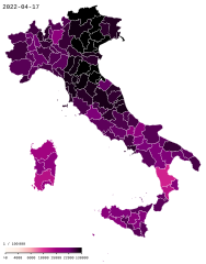
COVID-19 in Italy - cumulative confirmed cases by province per 100.000 inhabitants
Summary edit
| Description |
English: COVID19 in Italy - Cumulative positive cases per 100k residents by province. Gradient steps: >0 4,000 6,000 10,000 15,000 22,000 ≥ 30,000 |
| Data table | Data:COVID-19 Italy - Cases per capita.tab |
| Date | |
| Source |
|
| Author | Xplus1 |
| Other versions | |
| SVG development | This map was created with an unknown SVG tool. |
.svg)
.svg)
| Camera location | | View this and other nearby images on: OpenStreetMap |
|---|

|
This file may be updated to reflect new information. If you wish to use a specific version of the file without new updates being mirrored, please upload the required version as a separate file. |
Licensing edit
I, the copyright holder of this work, hereby publish it under the following license:
This file is licensed under the Creative Commons Attribution-Share Alike 4.0 International license.
- You are free:
- to share – to copy, distribute and transmit the work
- to remix – to adapt the work
- Under the following conditions:
- attribution – You must give appropriate credit, provide a link to the license, and indicate if changes were made. You may do so in any reasonable manner, but not in any way that suggests the licensor endorses you or your use.
- share alike – If you remix, transform, or build upon the material, you must distribute your contributions under the same or compatible license as the original.
File history
Click on a date/time to view the file as it appeared at that time.
| Date/Time | Thumbnail | Dimensions | User | Comment | |
|---|---|---|---|---|---|
| current | 16:32, 17 April 2022 | | 512 × 653 (126 KB) | XplusMapBot (talk | contribs) | data 2022-04-17, 15.417.311 total, map diff: 51.307 = 0.33% |
| 16:32, 16 April 2022 |  | 512 × 653 (126 KB) | XplusMapBot (talk | contribs) | data 2022-04-16, 15.366.004 total, map diff: 63.474 = 0.41% | |
| 16:32, 15 April 2022 |  | 512 × 653 (126 KB) | XplusMapBot (talk | contribs) | data 2022-04-15, 15.302.530 total, map diff: 61.147 = 0.40% | |
| 16:32, 14 April 2022 |  | 512 × 653 (126 KB) | XplusMapBot (talk | contribs) | data 2022-04-14, 15.241.383 total, map diff: 64.634 = 0.43% | |
| 16:32, 13 April 2022 |  | 512 × 653 (126 KB) | XplusMapBot (talk | contribs) | data 2022-04-13, 15.176.749 total, map diff: 61.567 = 0.41% | |
| 16:32, 12 April 2022 |  | 512 × 653 (126 KB) | XplusMapBot (talk | contribs) | data 2022-04-12, 15.115.182 total, map diff: 111.261 = 0.74% | |
| 16:32, 10 April 2022 |  | 512 × 653 (126 KB) | XplusMapBot (talk | contribs) | data 2022-04-10, 15.003.921 total, map diff: 55.927 = 0.37% | |
| 16:32, 9 April 2022 |  | 512 × 653 (126 KB) | XplusMapBot (talk | contribs) | data 2022-04-09, 14.947.994 total, map diff: 60.770 = 0.41% | |
| 16:32, 8 April 2022 |  | 512 × 653 (126 KB) | XplusMapBot (talk | contribs) | data 2022-04-08, 14.887.224 total, map diff: 66.643 = 0.45% | |
| 16:32, 7 April 2022 |  | 512 × 653 (126 KB) | XplusMapBot (talk | contribs) | data 2022-04-07, 14.820.581 total, map diff: 137.997 = 0.94% |
You cannot overwrite this file.
File usage on Commons
There are no pages that use this file.
File usage on other wikis
The following other wikis use this file:
- Usage on cs.wikipedia.org
- Usage on de.wikipedia.org
- Usage on es.wikipedia.org
- Usage on eu.wikipedia.org
- Usage on fr.wikipedia.org
- Usage on fr.wikinews.org
- Usage on ga.wikipedia.org
- Usage on id.wikipedia.org
- Usage on it.wikipedia.org
- Usage on ja.wikipedia.org
- Usage on lv.wikipedia.org
- Usage on nl.wikipedia.org
- Usage on pl.wikipedia.org
- Usage on pt.wikipedia.org
- Usage on simple.wikipedia.org
- Usage on su.wikipedia.org
- Usage on tl.wikipedia.org
- Usage on uz.wikipedia.org
- Usage on vi.wikipedia.org
- Usage on www.wikidata.org
- Usage on zh.wikipedia.org