File:Ca. 1870 map of Paris by Eugene Deschamps.jpg

Original file (36,607 × 26,981 pixels, file size: 230.44 MB, MIME type: image/jpeg)
Captions
Captions
Summary
edit
| Warning | The original file is very high-resolution. It might not load properly or could cause your browser to freeze when opened at full size. |
|---|
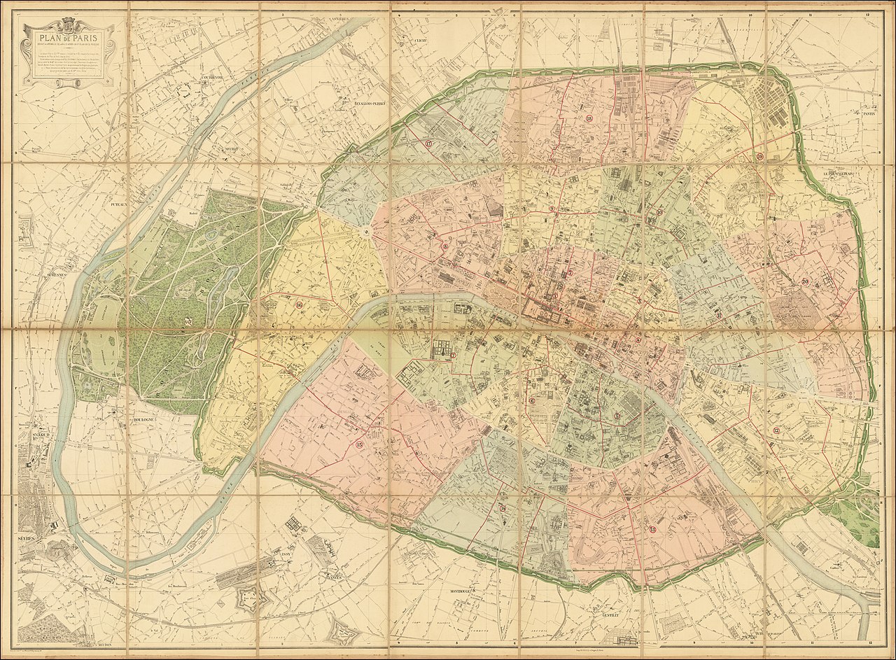
| Title |
Plan de Paris Reduit a l'Echellee de 1/10,000 D'Apres Le Gd. Plan En 21 Feuilles . . . deupuis 1842 |
| Description |
English: The Deschamps-Hausmann Plan of Paris
Important Early Modern Plan of Paris, prepared under the direction of Eugene Deschamps. Divided into Arrondissements, the plan provides an exacting depiction of Paris at the conclusion of the multi-decade modernization of Paris undertaken in the middle of the 19th Century. Deschamps plan illustrates the new layout of Paris, commissioned by Emperor Napoleon III and carried out by Baron Haussmann, prefect of the Seine. Between 1853 and 1870 the medieval streets of Paris were transformed into the modern city we know today, with wide tree-lined boulevards, squares and parks including the Bois de Boulogne. He also greatly improved the health of the citizens by creating new water and sewer systems. Hausmann appointed Eugene Deschamps as Conservateur de Paris. Under Deschamps direction, a comprehensive topographical and geometrical survey of Paris was conducted, beginning in 1853. As chief surveyor, Deschamps was substantially responsible for the modern plan of Paris. Deschamps and his team were responsible for planning the project as a whole and were largely responsible for the outcome. As noted by Haussman, "le Plan de Paris c'etait M. Deschamps." (Plan of Paris 'was M. Deschamps). The complete title of the map translates as follows: Map of Paris, reduced to a scale of 1: 10,000 according to the large plan in 21 sheets. The large plan in 21 sheets drawn up in scale of 1: 5,000 summarizes the work of the surveyors of the Plan de Paris since 1842. It was carried out under the direction of Mr. Eug. Deschamps head of the Paris Plan Service, by the care of Messrs. of Lucenay Ross and Chevigny triangulating surveyors Berger Montry Picard-Dobre and Pozier chief surveyors of the topographical brigades and L. Fauve, chief surveyor of the Interior Service in charge of reduction. It was engraved on stone by Messrs. Avril frères |
| Date | circa 1870 |
| Source | Barry Lawrence Ruderman Antique Maps Inc. |
| Creator |
Eugene Deschamps |
| Geotemporal data | |
| Map location | Paris |
| Georeferencing | If inappropriate please set warp_status = skip to hide. |
| Archival data | |
| Collection | Barry Lawrence Ruderman Antique Maps Inc. |
| Dimensions | 60 x 44 inches |
Licensing
edit
|
This work is in the public domain in its country of origin and other countries and areas where the copyright term is the author's life plus 100 years or fewer. | |
| This file has been identified as being free of known restrictions under copyright law, including all related and neighboring rights. | |
File history
Click on a date/time to view the file as it appeared at that time.
| Date/Time | Thumbnail | Dimensions | User | Comment | |
|---|---|---|---|---|---|
| current | 03:15, 20 April 2020 | | 36,607 × 26,981 (230.44 MB) | Balkanique (talk | contribs) | Uploaded a work by Eugene Deschamps from https://www.raremaps.com/gallery/detail/64352/plan-de-paris-reduit-a-lechellee-de-110000-dapres-le-gd-deschamps with UploadWizard |
You cannot overwrite this file.
File usage on Commons
The following page uses this file: