File:Calcasieu Pass, Louisiana LOC 80691506.tif

Size of this JPG preview of this TIF file: 421 × 599 pixels. Other resolutions: 168 × 240 pixels | 337 × 480 pixels | 539 × 768 pixels | 719 × 1,024 pixels | 1,438 × 2,048 pixels | 4,731 × 6,736 pixels.
Original file (4,731 × 6,736 pixels, file size: 91.18 MB, MIME type: image/tiff)
Captions
Captions
Add a one-line explanation of what this file represents
Summary edit
| Description |
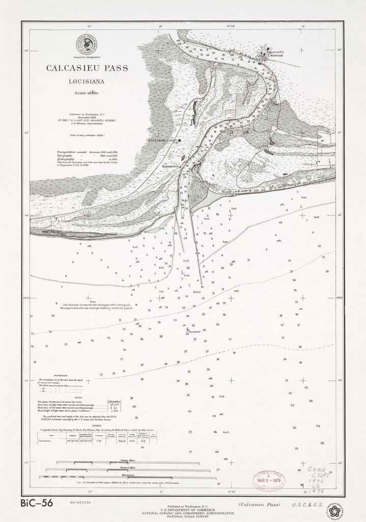
English: Scale 1:20,000. Title in lower margin: Calcasieu Pass. Facsimile. "American Revolution Bicentennial, 1776-1976." "Date of first publication 1889." Depths shown by soundings and contours. "BiC-56." Includes tide information. Available also through the Library of Congress Web site as a raster image. AACR2 |
||
| Title | Calcasieu Pass, Louisiana | ||
| Shelf ID | G4012.C32P5 1902 .U5 1976 | ||
| Date | |||
| Source | https://www.loc.gov/item/80691506/ | ||
| Author | U.S. Coast And Geodetic Survey; Tittmann, O. H. (Otto Hilgard); National Ocean Survey | ||
| Permission (Reusing this file) |
|
||
| Other versions |
|
||
| Location | United States · Calcasieu Pass · Louisiana · Calcasieu Pass. | ||
| Part of | American Memory · General Maps · Catalog · Geography And Map Division | ||
| Subject | Calcasieu Pass · Nautical Charts · Facsimiles · United States · Maps · Louisiana |


Licensing edit
This work is in the public domain in the United States because it is a work prepared by an officer or employee of the United States Government as part of that person’s official duties under the terms of Title 17, Chapter 1, Section 105 of the US Code.
Note: This only applies to original works of the Federal Government and not to the work of any individual U.S. state, territory, commonwealth, county, municipality, or any other subdivision. This template also does not apply to postage stamp designs published by the United States Postal Service since 1978. (See § 313.6(C)(1) of Compendium of U.S. Copyright Office Practices). It also does not apply to certain US coins; see The US Mint Terms of Use.
|
 | |
| This file has been identified as being free of known restrictions under copyright law, including all related and neighboring rights. | ||
File history
Click on a date/time to view the file as it appeared at that time.
| Date/Time | Thumbnail | Dimensions | User | Comment | |
|---|---|---|---|---|---|
| current | 07:31, 26 June 2019 |  | 4,731 × 6,736 (91.18 MB) | Fæ (talk | contribs) | LOC Maps https://www.loc.gov/item/80691506/ #16422 |
You cannot overwrite this file.
File usage on Commons
The following page uses this file: