File:Calvisson-Moulin de Cassini-20210401.jpg

Size of this preview: 800 × 533 pixels. Other resolutions: 320 × 213 pixels | 640 × 427 pixels | 1,024 × 683 pixels | 1,280 × 853 pixels | 2,560 × 1,707 pixels | 5,232 × 3,488 pixels.
Original file (5,232 × 3,488 pixels, file size: 21.25 MB, MIME type: image/jpeg)
Captions
Captions
Add a one-line explanation of what this file represents
Summary
edit
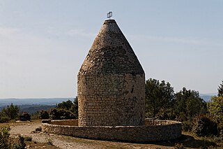
| Description | The sharp mill is wearing a geodesic marker, useless now (replaced by a reference to stall for the GPS). |
| Date | Taken on 1 April 2021 |
| Source | Own work. |
| Author | Daniel VILLAFRUELA. |
| Object location | | View this and other nearby images on: OpenStreetMap |
|---|
| Camera location | | View this and other nearby images on: OpenStreetMap |
|---|
Licensing
edit
Daniel VILLAFRUELA, the copyright holder of this work, hereby publishes it under the following license:
This file is licensed under the Creative Commons Attribution-Share Alike 4.0 International license.
Attribution: Daniel VILLAFRUELA
- You are free:
- to share – to copy, distribute and transmit the work
- to remix – to adapt the work
- Under the following conditions:
- attribution – You must give appropriate credit, provide a link to the license, and indicate if changes were made. You may do so in any reasonable manner, but not in any way that suggests the licensor endorses you or your use.
- share alike – If you remix, transform, or build upon the material, you must distribute your contributions under the same or compatible license as the original.
File history
Click on a date/time to view the file as it appeared at that time.
| Date/Time | Thumbnail | Dimensions | User | Comment | |
|---|---|---|---|---|---|
| current | 07:45, 13 April 2021 | | 5,232 × 3,488 (21.25 MB) | Daniel VILLAFRUELA (talk | contribs) | {{Information |Description = {{LangSwitch |en= The sharp mill is wearing a geodesic marker, useless now (replaced by a reference to stall for the GPS). |es= Molino afilado lleva un marcador geodésico.,inútil ahora (sustituido por una referencia a estancar el GPS). |fr= Le moulin pointu, est coiffé d'un repère géodésique, inutile maintenant (remplacé par un repère destiné à caler les satellites du réseau GPS). }} {{Information field|Name=Détails|Value= <gallery> File:Calvisson-Plaque funéraire... |
You cannot overwrite this file.
File usage on Commons
The following page uses this file: