File:Camps topographiques de la campagne de MDCCLVII, en Westphalie 1757, 09, 18, Camp de Stockem - detail rotated.jpg

Size of this preview: 800 × 527 pixels. Other resolutions: 320 × 211 pixels | 640 × 421 pixels | 1,024 × 674 pixels | 1,280 × 843 pixels | 2,560 × 1,686 pixels | 3,232 × 2,128 pixels.
Original file (3,232 × 2,128 pixels, file size: 6.41 MB, MIME type: image/jpeg)
Captions
Captions
Add a one-line explanation of what this file represents
Summary
edit| Description |
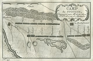
English: Edited topographic map of the camps, No. 45, in the Seven Years War in 1757 and 1758
(edited detail: cropped borders and rotation of 181.25 deg clockwise; re-rotating of some text and of upper right plaque) Deutsch: Bearbeitete topografische Karte No. 45 der Feldlager im Siebenjährigen Krieg
Français : Camps topographiques No. 45 de la Campagne de de MDCCLVII, en Westphalie (edited) |
||||||||||||||||||||||
| Date | |||||||||||||||||||||||
| Source |
|
||||||||||||||||||||||
| Author |
|
||||||||||||||||||||||
| Other versions |
|
||||||||||||||||||||||


| Object location | | View this and other nearby images on: OpenStreetMap |
|---|
Licensing
edit
|
This work is in the public domain in its country of origin and other countries and areas where the copyright term is the author's life plus 100 years or fewer. | |
| This file has been identified as being free of known restrictions under copyright law, including all related and neighboring rights. | |
File history
Click on a date/time to view the file as it appeared at that time.
| Date/Time | Thumbnail | Dimensions | User | Comment | |
|---|---|---|---|---|---|
| current | 22:37, 8 February 2014 | | 3,232 × 2,128 (6.41 MB) | Jaybear (talk | contribs) | {{Information |Description ={{en|1=Topographic map of the camps in the Seven Years War in 1757 and 1758 <br /> (edited detail: cropped borders and rotation about 180 deg clockwise; re-rotating of some text and of upper right plaque)}} |Source... |
You cannot overwrite this file.
File usage on Commons
The following 4 pages use this file:
- User talk:Bernd Schwabe in Hannover/Archive 01
- User talk:Bernd Schwabe in Hannover/Archive 2
- File:Camps topographiques de la campagne de MDCCLVII, en Westphalie. 1757, 09, 18. Camp de Stockem.jpg
- File:Camps topographiques de la campagne de MDCCLVII, en Westphalie 1757, 09, 18, Camp de Stockem - detail.jpg
File usage on other wikis
The following other wikis use this file:
- Usage on de.wikipedia.org