File:Canada 2013 Steveston--Richmond East.svg

Size of this PNG preview of this SVG file: 500 × 400 pixels. Other resolutions: 300 × 240 pixels | 600 × 480 pixels | 960 × 768 pixels | 1,280 × 1,024 pixels | 2,560 × 2,048 pixels.
Original file (SVG file, nominally 500 × 400 pixels, file size: 4.99 MB)
Captions
Captions
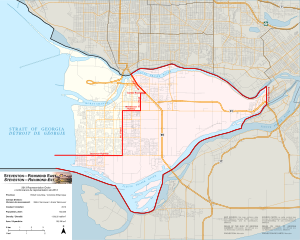
Federal district of Steveston—Richmond East and vicinity.
Summary
edit
| Description |
English: A detailed SVG map depicting the boundaries of the Steveston—Richmond East federal electoral district in relation to its bordering districts as of the 2013 representational order.
Français : Un carte détaillé en format SVG qui illustre les frontières de la circonscription fédérale Steveston—Richmond-Est et ses circonscriptions voisins à compter de l'ordonnance de représentation de 2013. |
| Date | |
| Source | Own work, based on files from Statistics Canada and OpenStreetMap. Image of the Gulf of Georgia Cannery is courtesy of CDCook48, CC BY-SA 4.0, via Wikimedia Commons. |
| Author | Eric Tian (Eric0892) |
Licensing
edit
I, the copyright holder of this work, hereby publish it under the following license:
This file is licensed under the Creative Commons Attribution-Share Alike 4.0 International license.
- You are free:
- to share – to copy, distribute and transmit the work
- to remix – to adapt the work
- Under the following conditions:
- attribution – You must give appropriate credit, provide a link to the license, and indicate if changes were made. You may do so in any reasonable manner, but not in any way that suggests the licensor endorses you or your use.
- share alike – If you remix, transform, or build upon the material, you must distribute your contributions under the same or compatible license as the original.
File history
Click on a date/time to view the file as it appeared at that time.
| Date/Time | Thumbnail | Dimensions | User | Comment | |
|---|---|---|---|---|---|
| current | 04:10, 20 October 2023 | | 500 × 400 (4.99 MB) | Eric0892 (talk | contribs) | Uploaded own work with UploadWizard |
You cannot overwrite this file.
File usage on Commons
The following page uses this file:
File usage on other wikis
The following other wikis use this file:
- Usage on en.wikipedia.org
- Usage on fr.wikipedia.org