File:Canadian French distribution in the US and Canada.png

Size of this preview: 600 × 600 pixels. Other resolutions: 240 × 240 pixels | 480 × 480 pixels | 768 × 768 pixels | 1,024 × 1,024 pixels.
Original file (1,024 × 1,024 pixels, file size: 195 KB, MIME type: image/png)
Captions
Captions
Add a one-line explanation of what this file represents
Summary edit
| Description |
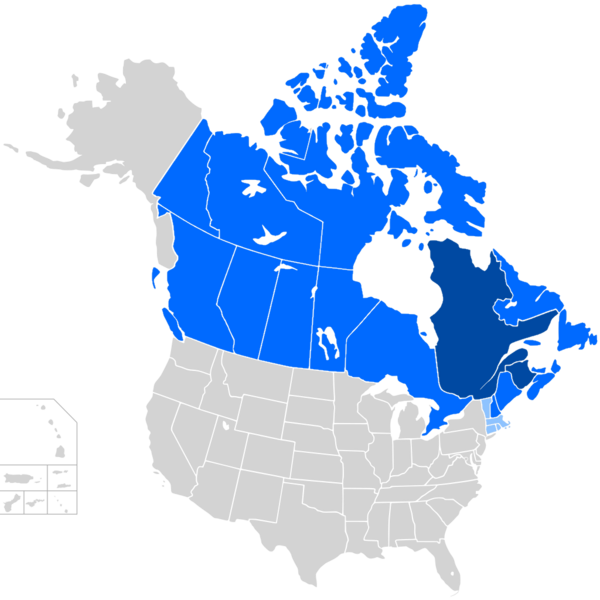
English: Canadian French distribution in the United States and Canada.
Regions where Canadian French is the main language (Quebec and New Brunswick)
Regions where Canadian French is an official language but not a majority native language (rest of Canada, Maine, and New Hampshire)
Regions where it is a minority language (rest of New England) |
| Date | |
| Source |
Map: File:BlankMap-USA-states-Canada-provinces,_HI_closer.svg Data: Canadian French |
| Author | Derived work: User:Soumya-8974 |
Licensing edit
This file is licensed under the Creative Commons Attribution-Share Alike 2.5 Generic license.
- You are free:
- to share – to copy, distribute and transmit the work
- to remix – to adapt the work
- Under the following conditions:
- attribution – You must give appropriate credit, provide a link to the license, and indicate if changes were made. You may do so in any reasonable manner, but not in any way that suggests the licensor endorses you or your use.
- share alike – If you remix, transform, or build upon the material, you must distribute your contributions under the same or compatible license as the original.
File history
Click on a date/time to view the file as it appeared at that time.
| Date/Time | Thumbnail | Dimensions | User | Comment | |
|---|---|---|---|---|---|
| current | 14:50, 7 June 2020 | | 1,024 × 1,024 (195 KB) | Sbb1413 (talk | contribs) | Forgot to color some of the Canadian islands. |
| 13:47, 7 June 2020 |  | 1,024 × 1,024 (195 KB) | Sbb1413 (talk | contribs) | Uploaded a work by '''Derived work:''' User:Soumya-8974 from '''Map:''' with UploadWizard |
You cannot overwrite this file.
File usage on Commons
The following 2 pages use this file:
File usage on other wikis
The following other wikis use this file:
- Usage on en.wikipedia.org
- Usage on et.wikipedia.org