File:Canadian Trail.jpg

Size of this preview: 412 × 599 pixels. Other resolutions: 165 × 240 pixels | 330 × 480 pixels | 986 × 1,434 pixels.
Original file (986 × 1,434 pixels, file size: 877 KB, MIME type: image/jpeg)
Captions
Captions
Add a one-line explanation of what this file represents
Summary
edit
| Description |
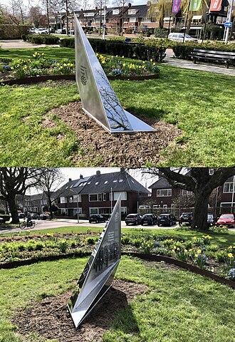
Nederlands: Dit monument markeert de route die de Canadese bevrijders in 1945 hebben afgelegd in de provincie Fryslân. Van De Blesse tot aan het Lauwersmeer (was toen Lauwerszee). Op de 250 kilometer lange route zijn op meerdere plaatsen zulke markeringspunten met oorlog's verhalen geplaatst . De Canadian Trail is onderdeel van een netwerk van wandelroutes langs plekken die met de tweede wereldoorlog te maken hebben. |
| Date | |
| Source | Own work |
| Author | Ytzen |
Licensing
edit
I, the copyright holder of this work, hereby publish it under the following license:
This file is licensed under the Creative Commons Attribution-Share Alike 4.0 International license.
- You are free:
- to share – to copy, distribute and transmit the work
- to remix – to adapt the work
- Under the following conditions:
- attribution – You must give appropriate credit, provide a link to the license, and indicate if changes were made. You may do so in any reasonable manner, but not in any way that suggests the licensor endorses you or your use.
- share alike – If you remix, transform, or build upon the material, you must distribute your contributions under the same or compatible license as the original.
File history
Click on a date/time to view the file as it appeared at that time.
| Date/Time | Thumbnail | Dimensions | User | Comment | |
|---|---|---|---|---|---|
| current | 11:30, 13 April 2023 | | 986 × 1,434 (877 KB) | Ytzen (talk | contribs) | Uploaded own work with UploadWizard |
You cannot overwrite this file.
File usage on Commons
The following page uses this file:
File usage on other wikis
The following other wikis use this file:
- Usage on nl.wikipedia.org
- Usage on www.wikidata.org