File:Cani Islands Aerial-Cropted.jpg

Size of this preview: 800 × 531 pixels. Other resolutions: 320 × 213 pixels | 640 × 425 pixels | 1,024 × 680 pixels | 1,280 × 850 pixels | 2,560 × 1,700 pixels | 4,288 × 2,848 pixels.
Original file (4,288 × 2,848 pixels, file size: 6.48 MB, MIME type: image/jpeg)
Captions
Captions
Add a one-line explanation of what this file represents
| Description |
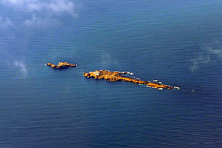
Deutsch: Luftaufnahme der Cani-Inseln (Tunesien) im Mittelmeer English: Aerial view of Cani Islands (Tunisia) in the Mediterranean Français : Les Îles Cani au large de Cap Zebib, nord-est Tunisie |
| Date | (UTC) |
| Source | |
| Author |
|
| This is a retouched picture, which means that it has been digitally altered from its original version. Modifications: Cropted and contrast. The original can be viewed here: Cani Islands Aerial.jpg:
|
I, the copyright holder of this work, hereby publish it under the following license:
This file is licensed under the Creative Commons Attribution-Share Alike 2.0 Generic license.
- You are free:
- to share – to copy, distribute and transmit the work
- to remix – to adapt the work
- Under the following conditions:
- attribution – You must give appropriate credit, provide a link to the license, and indicate if changes were made. You may do so in any reasonable manner, but not in any way that suggests the licensor endorses you or your use.
- share alike – If you remix, transform, or build upon the material, you must distribute your contributions under the same or compatible license as the original.
Original upload log
edit
This image is a derivative work of the following images:
- File:Cani_Islands_Aerial.jpg licensed with Cc-by-sa-2.0
- 2009-05-19T12:16:18Z FlickreviewR 4288x2848 (6145915 Bytes) Replacing image by its original image from Flickr
- 2009-05-19T10:53:52Z Telim tor 1024x680 (394607 Bytes) == Beschreibung == {{Information |Description= {{de|Luftaufnahme der Cani-Inseln (Tuinesien) im Mittelmeer}} {{en|Aerial view of cani Islands (Tunusia) in the Mediterranean}} |Source=[http://www.flickr.com/photos/t_abdelmoume
Uploaded with derivativeFX
File history
Click on a date/time to view the file as it appeared at that time.
| Date/Time | Thumbnail | Dimensions | User | Comment | |
|---|---|---|---|---|---|
| current | 00:38, 25 January 2013 | | 4,288 × 2,848 (6.48 MB) | Slick-o-bot (talk | contribs) | Bot: convert to a non-interlaced jpeg (see bug #17645) |
| 18:31, 28 September 2009 |  | 4,288 × 2,848 (6.01 MB) | M0tty (talk | contribs) | {{Information |Description={{de|Luftaufnahme der Cani-Inseln (Tunesien) im Mittelmeer}} {{en|Aerial view of Cani Islands (Tunisia) in the Mediterranean}} {{fr|Les Îles Cani au large de Cap Zebib, nord-est Tunisie}} |Source=*[[:File:Cani_Islands_Aerial.jp |
You cannot overwrite this file.
File usage on Commons
The following page uses this file:
File usage on other wikis
The following other wikis use this file:
- Usage on ar.wikipedia.org
- Usage on ca.wikipedia.org
- Usage on ceb.wikipedia.org
- Usage on cy.wikipedia.org
- Usage on de.wikipedia.org
- Usage on es.wikipedia.org
- Usage on fr.wikipedia.org
- Usage on it.wikipedia.org
- Usage on sv.wikipedia.org
- Usage on www.wikidata.org