File:Canton town map 1748-49 enhanced with translations.jpg

Original file(3,586 × 3,614 pixels, file size: 8.01 MB, MIME type: image/jpeg)

Captions

Captions

Add a one-line explanation of what this file represents

Summary edit

Description
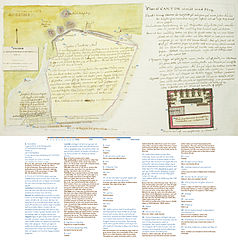
English: Map of Canton from a diary by the command of the Royal Swedish Academy of Sciences, written by Johan Friedrich Dalman, during the journey from Gothenburg to Canton and back, starting 19 February 1748 and ending 11 July 1749, on the Swedish East India Company ship Freden. Transcribed text and translation by W.carter.

Transcription of Swedish text and translation. The text is written in 18th century Swedish and the translation is rather direct, which can make the English sound a bit off in some places:

  • A. DAGBOK
Uppå KONGLIVETENSKAPS ACADEMIENS befalning Hållen af Joh:Frid:Daalman Under Resan från Giötheborg til CANTON och Hem som började År 1748 d. 19 Febr. och slutades År 1749 d. 11 July

Diary by the command of the (Swedish) Royal Academy of Science. Written by Johan Friedrich Dalman. During the journey from Gothenburg to Canton and back, starting 19 February 1748 and ended 11 July 1749 (On the Swedish East India Company ship Freden)

  • 1. PLAN af CANTON afmät med steg
Landet kring Canton är helt slätt så när som på norra sedan där äro tre högder som hvardera har sitt Castel och högt berg hvarpå är en pagode. Jordmånen deromkring är på Högvallen röd jord eller sand, men där som är sankt är den muddrig lera hvaruti riset väl trives. Reveriet har muddrig botten och förer et osunt vatten, ty om man lägger socker uti en kop med vatten och låter det stå en natt skal man om morgonen se en tjock blå hinna därpå. Där går stark ebb och flod så at vattnet stiger och faller half annor famn ibland i revieret, där äro åtskilliga grunder på hvilka man med en slup kan fasna. Folkets myckna badande måste väl ock bidraga något til at gjöra vattnet fett. Skjeppen ligga ett gått stycke nerom staden vid ett ställe som heter Vampo där föres folk och varor mellan staden och Skeppet på Chinesiska båtar eller sjampaner. Då äro på vägen tre tullhus hos hvilka man både vid up och ner resan måste låta visitera sig. Desutom ligger både vid Skeppet och Factorie brygga besökare sjampaner. Castellet som ligger vid sjön var jag uppe uti där var en tatarisk soldat som ville hindra och sade at mandarin vil ej. men gemena folket tog mig och min Camerat vid handen och ledde oss up. detta Castellet var 30 alnar på sida af gråsten.

Map of Canton measured in steps The countryside around Canton is rather flat with the exception of the north side where there are three hills, each with a Citadel and a high mountain with a pagoda. The soil in the area is red dirt or sand in the higher areas, but where it is marshy it is muddy clay where the rice thrives. The River has a muddy bottom and the water is unhealthy, for if you were to put sugar in a cup of water and leave it during the night, there is a thick blue scum on it the next morning. The tide is strong and the water in the river rise and fall almost half a fathom (0.91 meter), there are numerous shallows on which a sloop can get stuck. The peoples' excessive bathing must to some extent contribute to make the water greasy. The Ships are a long way downstream from the town at a place called Whampoa where people and goods are ferried between the town and the Ship on Chinese boats or sampans. On the way there are three customs houses at which you have to be examined both on the way up and down the river. At both the Ship and the Factory there are visiting sampans. I was up in The Citadel by the water, there was a Tatar soldier who stopped us and said that mandarin does not want but the common people took me and my companion by the hand and led us up. This Citadel was 30 ells (17.8 meter) on each side and made from grey stone.

  • 2. Pagoda på et högt berg
Pagoda on a high mountain
  • 3. Europeisk Begrafnings Plats
European burial ground
  • 4. Castel
Citadel
  • 5. Castel
Citadel
  • 6. Castel
Citadel
  • 7. här går Stora Lands vägen
This is where the Main Road is
  • 8. Port
Gate
  • 9. Fyrkantigt Torn
A square tower
  • 10. Port
Gate
  • 11. Et hus med tälter och gevär, Befäst med ett bröstvärn. Här öfvas Ryttarna.
A house with tents and rifles, fortified with a parapet. The riders train here.
  • 12. Stall
Stable
  • 13. Små hus
Small houses
  • 14. Små hus
Small houses
  • 15. Port
Gate
  • 16. Sjelfva Cantons Stad är rundtomgifven med höga gråstens murar hvilka äro ofvanpå besatte med stycken. där äro små bastioner utan facer. portarna äro alltid dubbelt murade så at mellan båda murarne är liksom en rund borggål, derinne är Corteyarde. Men som jag nedre sidan ej fynnit sådant ty tror jag at den öfre Staden är Tatariska så långt som til denna linean.
The town itself is surrounded by high walls of grey stone which are crenellated at the crest. There are small bastions without openings. The gates are made of double walls in such fashion that the walls form a sort of a round area with a courtyard within. But since I have not found such things in the lower part of the town, I believe the town to be Tartar as far as this line.
  • 17. under denna linean vid pass lärer Chinesiska Staden vara där äro bara enkla portar, när man ser in genom någon ser man gatorne gå raka och husen vara bygda lika som i förstaden, man får ej komma många steg in för än Mandarinernes betjenter komma ut med pikar säga desa orden Mandarin no quere. vai! vai! vai! hvilket betyder Mandarin vil intet. gå! gå! gå! Chineserne som man råkar gjöra tecken och ropa vai! Hela Stadens omkrets är 10400 steg eller 5200 famnar
Below this line is the Chinese town. Here are only simple gates and when you look through them, you see that the streets are straight and the houses are built like in the suburb. You can not enter many steps before the Mandarins' guards come out with pikes and say these words Mandarin no quere. vai! vai! vai! which means Mandarin does not want. Go! Go! Go! The Chinese that you meet also make signs and yell vai! The total circumference of the town is 10400 steps or 5200 fathoms. (9480 meter)
  • 18. Pagode
Pagoda
  • 19. Här åro helt små hus
Here are rather small houses
  • 20. Förstad tämmeligen väl bygder här uppe bo manufacturister men de tre gatorne som äro näst til Sjön frequenteras endast af Europeerne. Den som är närmast Sjön kallas Factoriegatan där bo alla Europeer, men den närmaste hit är uppfylld med porcellinsbodar och kallas derföre Porcellinsgatan.
Suburb, rather well built. Up here lives manufacturers but the three streets closest to the water are only frequented by the Europeans. The one nearest to the street is called the Factory Street. There lives all the Europeans, but the one nearest here is filled with porcelain shops and is therefore called Porcelain Street.
  • 21. Castel
Citadel
  • 22. här löper Cantons Rivier
Here runs Canton River
  • 23. vid denna tracten är ock Castel och Tullhus
In this area are also a Citadel and a Customs house
  • 24. Förstad. här äro Sjampan varf.
Suburb. Here are sampan wharfs.
  • 25. Scala af Steg som två gjöra vid pass en Famn.
Scale in steps of which two make one fathom (A Swedish fathom on land is slightly different from the English; it is equal to 1.823 meter)
  • 26. Redskap
Tools
  • 27. Små mortare
Small mortars
  • 28. Trappa up
Stairs up
  • 29. Här äro kamrar hvareft Commendanten och Soldaterne bo
Here are two chambers where the Commander and the Soldiers live.
  • 30. Nedomkring var en fotmur 2 alnar bred
Around the base was a wall 2 ells wide (1.2 meter)
  • 31. här öfvas Soldaterne at skjuta med båga til måls
Here, soldiers are trained to shoot with bows at targets
Date
Source http://www.ub.gu.se/samlingar/handskrift/ostindie/bildvisning/djvu.xml?id=187&doc=187&page=1
Author Johan Friedrich Dalman
Other versions
Canton maps
Canton town map 1748-49 original
Canton town map 1748-49 enhanced with translations
Canton Thirteen Factories map 1748-49 original
Canton Thirteen Factories map 1748-49 enhanced with translations

Licensing edit

Public domain

This work is in the public domain in its country of origin and other countries and areas where the copyright term is the author's life plus 70 years or fewer.


You must also include a United States public domain tag to indicate why this work is in the public domain in the United States. Note that a few countries have copyright terms longer than 70 years: Mexico has 100 years, Jamaica has 95 years, Colombia has 80 years, and Guatemala and Samoa have 75 years. This image may not be in the public domain in these countries, which moreover do not implement the rule of the shorter term. Honduras has a general copyright term of 75 years, but it does implement the rule of the shorter term. Copyright may extend on works created by French who died for France in World War II (more information), Russians who served in the Eastern Front of World War II (known as the Great Patriotic War in Russia) and posthumously rehabilitated victims of Soviet repressions (more information).

This is a faithful photographic reproduction of a two-dimensional, public domain work of art. The work of art itself is in the public domain for the following reason:
Public domain

This work is in the public domain in its country of origin and other countries and areas where the copyright term is the author's life plus 100 years or fewer.


You must also include a United States public domain tag to indicate why this work is in the public domain in the United States.
The official position taken by the Wikimedia Foundation is that "faithful reproductions of two-dimensional public domain works of art are public domain".
This photographic reproduction is therefore also considered to be in the public domain in the United States. In other jurisdictions, re-use of this content may be restricted; see Reuse of PD-Art photographs for details.

File history

Click on a date/time to view the file as it appeared at that time.

Date/TimeThumbnailDimensionsUserComment
current15:40, 31 December 2014Thumbnail for version as of 15:40, 31 December 20143,586 × 3,614 (8.01 MB)W.carter (talk | contribs)Some copyedit, corrections and additions in the text
17:26, 10 November 2014Thumbnail for version as of 17:26, 10 November 20143,586 × 3,614 (7.95 MB)W.carter (talk | contribs)User created page with UploadWizard

File usage on other wikis

The following other wikis use this file:

Metadata