File:Carbon Peak geologic cross section USGS 1987.jpg

Size of this preview: 799 × 221 pixels. Other resolutions: 320 × 89 pixels | 1,640 × 454 pixels.
Original file (1,640 × 454 pixels, file size: 267 KB, MIME type: image/jpeg)
Captions
Captions
Add a one-line explanation of what this file represents
Summary
edit
| Description |
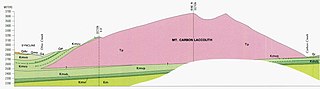
English: Geologic cross section of Carbon Peak, a laccolith, from NW to SE. Consolidated rocks and formations include: Tp, Tertiary quartz monzonite porphyry and granodiorite porphyry (igneous intrusives); Kmv*, Mesaverde Formation; and Km, Mancos Shale. Carbon Peak is located in the West Elk Mountains of Colorado, USA. |
| Date | |
| Source | Gaskill, D.L., Delong, J.E., Jr, and Cochran, D.M.. 1987. Geologic map of the Mt. Axtell quadrangle, Gunnison County, Colorado. Geologic Quadrangle Map GQ-1604. U.S. Geological Survey, Reston, Virginia. |
| Author | Gaskill, D.L., Delong, J.E., and Cochran, D.M. |
Licensing
edit
This image is in the public domain in the United States because it only contains materials that originally came from the United States Geological Survey, an agency of the United States Department of the Interior. For more information, see the official USGS copyright policy.
|
File history
Click on a date/time to view the file as it appeared at that time.
| Date/Time | Thumbnail | Dimensions | User | Comment | |
|---|---|---|---|---|---|
| current | 00:31, 22 November 2020 | 1,640 × 454 (267 KB) | Zapus (talk | contribs) | Uploaded a work by Gaskill, D.L., Delong, J.E., and Cochran, D.M. from https://ngmdb.usgs.gov/Prodesc/proddesc_1129.htm Gaskill, D.L., Delong, J.E., Jr, and Cochran, D.M.. 1987. Geologic map of the Mt. Axtell quadrangle, Gunnison County, Colorado. Geologic Quadrangle Map GQ-1604. U.S. Geological Survey, Reston, Virginia. with UploadWizard |
You cannot overwrite this file.
File usage on Commons
There are no pages that use this file.
File usage on other wikis
The following other wikis use this file:
- Usage on en.wikipedia.org