File:Carn a' Mhaim - geograph.org.uk - 1142257.jpg
No higher resolution available.
Carn_a'_Mhaim_-_geograph.org.uk_-_1142257.jpg (640 × 410 pixels, file size: 65 KB, MIME type: image/jpeg)
Captions
Captions
Add a one-line explanation of what this file represents
Summary edit
| Description |
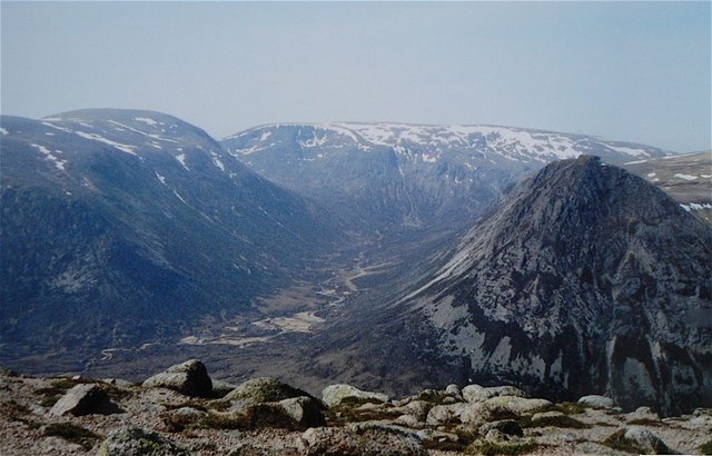
English: Carn a' Mhaim The bouldery summit ridge of Carn a' Mhaim shows well the nature of much of the underfoot conditions in the Cairngorms, Big granite boulders with course granite sand between. Patches of vegetation surround the boulders, benefitting from shelter and the water which drips off the stones during hill fog conditions, helping to make up for the well drained nature of the soil. The background features are L to R, Beinn Bhrotain, Monadh Mòr, Glen Geusachan and the Devil's Point |
| Date | |
| Source | From geograph.org.uk |
| Author | AlastairG |
| Attribution (required by the license) | AlastairG / Carn a' Mhaim / |
| Camera location | | View this and other nearby images on: OpenStreetMap |
|---|
_heading:247.00&language=en)
| Object location | | View this and other nearby images on: OpenStreetMap |
|---|
_heading:247.00&language=en)
Licensing edit

|
This image was taken from the Geograph project collection. See this photograph's page on the Geograph website for the photographer's contact details. The copyright on this image is owned by AlastairG and is licensed for reuse under the Creative Commons Attribution-ShareAlike 2.0 license.
|
This file is licensed under the Creative Commons Attribution-Share Alike 2.0 Generic license.
Attribution: AlastairG
- You are free:
- to share – to copy, distribute and transmit the work
- to remix – to adapt the work
- Under the following conditions:
- attribution – You must give appropriate credit, provide a link to the license, and indicate if changes were made. You may do so in any reasonable manner, but not in any way that suggests the licensor endorses you or your use.
- share alike – If you remix, transform, or build upon the material, you must distribute your contributions under the same or compatible license as the original.
File history
Click on a date/time to view the file as it appeared at that time.
| Date/Time | Thumbnail | Dimensions | User | Comment | |
|---|---|---|---|---|---|
| current | 06:38, 25 February 2011 | | 640 × 410 (65 KB) | GeographBot (talk | contribs) | == {{int:filedesc}} == {{Information |description={{en|1=Carn a' Mhaim The bouldery summit ridge of Carn a' Mhaim shows well the nature of much of the underfoot conditions in the Cairngorms, Big granite boulders with course granite sand between. Patches |
You cannot overwrite this file.
File usage on Commons
There are no pages that use this file.