File:Carta Jeográfica De Los Estados Unidos De Colombia (right part).jpg

Size of this preview: 329 × 599 pixels. Other resolutions: 132 × 240 pixels | 264 × 480 pixels | 422 × 768 pixels | 562 × 1,024 pixels | 1,125 × 2,048 pixels | 10,354 × 18,844 pixels.
Original file (10,354 × 18,844 pixels, file size: 25.37 MB, MIME type: image/jpeg)
Captions
Captions
Add a one-line explanation of what this file represents
Summary
edit.jpg&action=edit§ion=1)
| Warning | The original file is very high-resolution. It might not load properly or could cause your browser to freeze when opened at full size. |
|---|
.jpg&flash=no)
| Description |
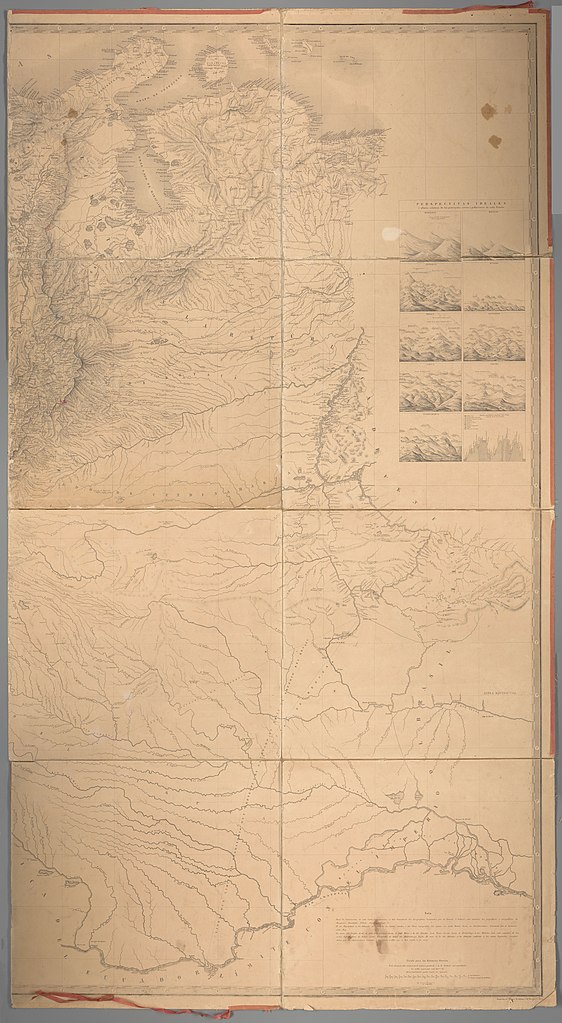
Deutsch: 1 Kt. : unkolor. (166 x 151 cm, gefaltet 43 x 39 cm). Maßstab 1 : 1 350 000. Koordinaten W 83°49'00"-W 74°12'00"/N 13°27'00"-S 1°25'00". Maßstab in graph. Form (miriámetros, antiguas leguas granadinas). Titel unten links. Maßstab und Anmerkung unten rechts. Auf Leinen aufgezogen. Mit 9 Ansichten: Magdalena. Bolivar. Antioquia. Panama. Boyacá. Santander. Cauca. Tolima. Cundinamarca. Mit 1 Statistik: Corte jeológico jeneral del Pais. Relief: Schraffen. Altkarte. |
| Date | |
| Source | Leibniz-Institut für Länderkunde e.V., Leipzig |
| Author | Codazzi, Agustín ; Ponce de León, Manuel ; Paz, Manuel Maria ; Murillo Toro, Manuel (Herausgeber/-in) ; Mosquera, Tomás Cipriano de |
Licensing
edit.jpg&action=edit§ion=2)
| This file is made available under the Creative Commons CC0 1.0 Universal Public Domain Dedication. | |
| The person who associated a work with this deed has dedicated the work to the public domain by waiving all of their rights to the work worldwide under copyright law, including all related and neighboring rights, to the extent allowed by law. You can copy, modify, distribute and perform the work, even for commercial purposes, all without asking permission.
|
File history
Click on a date/time to view the file as it appeared at that time.
| Date/Time | Thumbnail | Dimensions | User | Comment | |
|---|---|---|---|---|---|
| current | 10:59, 30 April 2019 | | 10,354 × 18,844 (25.37 MB) | Higgenhorscht (talk | contribs) | User created page with UploadWizard |
You cannot overwrite this file.
File usage on Commons
There are no pages that use this file.
.jpg&oldid=849154867)