File:Carta geométrica de Galicia dividida en sus provincias 1845. Con el trazado de ferro-carriles y carreteras kilometradas año de 1917.tif

Original file (12,903 × 14,449 pixels, file size: 20.7 MB, MIME type: image/tiff)
Captions
Captions
Summary edit
| Warning | The original file is very high-resolution. It might not load properly or could cause your browser to freeze when opened at full size. |
|---|
| Description |
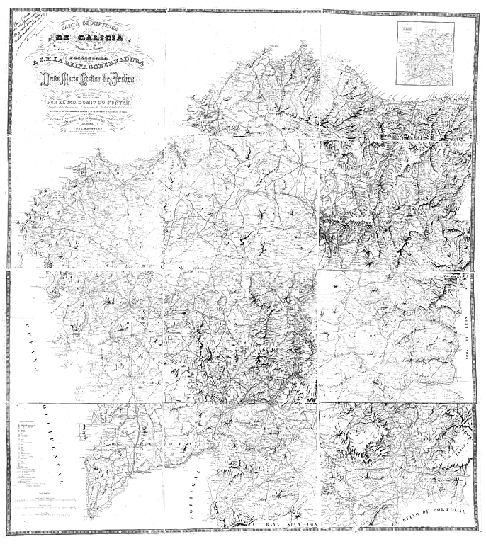
Español: Carta geométrica de Galicia, de Domingo Fontán, 1845.
Galego: Carta xeométrica de Galicia, de Domingo Fontán, 1845.
CARTA GEOMETRICA D E G A L I C I A Dividida en sus Provincias Doña Maria Cristina de Borbon por su Secretario de Estado y del despacho de lo Interior en 1845 POR L. BOUFFARD |
|||||||||||||||||||||||
| Date | 1834, 1845, 1917 | |||||||||||||||||||||||
| Source | Galiciana. Biblioteca Dixital de Galicia | |||||||||||||||||||||||
| Author |
|
|||||||||||||||||||||||
| Permission (Reusing this file) |
|
|||||||||||||||||||||||
,_por_Antonio_Mar%C3%ADa_Esquivel.jpg)
Other versions edit
 |
 |

|
 |
 |

|
 |
 |

|
 |
 |

|
File history
Click on a date/time to view the file as it appeared at that time.
| Date/Time | Thumbnail | Dimensions | User | Comment | |
|---|---|---|---|---|---|
| current | 22:12, 29 November 2016 |  | 12,903 × 14,449 (20.7 MB) | HombreDHojalata (talk | contribs) | |
| 22:08, 29 November 2016 |  | 12,903 × 14,449 (20.7 MB) | HombreDHojalata (talk | contribs) | =={{int:filedesc}}== {{Information |description={{es|1=Carta geométrica de Galicia, de Domingo Fontán, 1845.}} {{gl|1=Carta xeométrica de Galicia, de Domingo Fontán, 1845.}}<br /> '''Manuscrito: "''Con el trazado de ferro-carriles y carreteras ki... |
You cannot overwrite this file.
File usage on Commons
There are no pages that use this file.
File usage on other wikis
The following other wikis use this file:
- Usage on gl.wikipedia.org
- Usage on pt.wikipedia.org