File:Carte-Tram-Casa2019.png
Size of this preview: 800 × 523 pixels. Other resolutions: 320 × 209 pixels | 640 × 418 pixels | 1,024 × 670 pixels | 1,280 × 837 pixels | 2,560 × 1,674 pixels | 5,200 × 3,400 pixels.
Original file (5,200 × 3,400 pixels, file size: 6.47 MB, MIME type: image/png)
Captions
Captions
Add a one-line explanation of what this file represents
Summary edit
| Description |
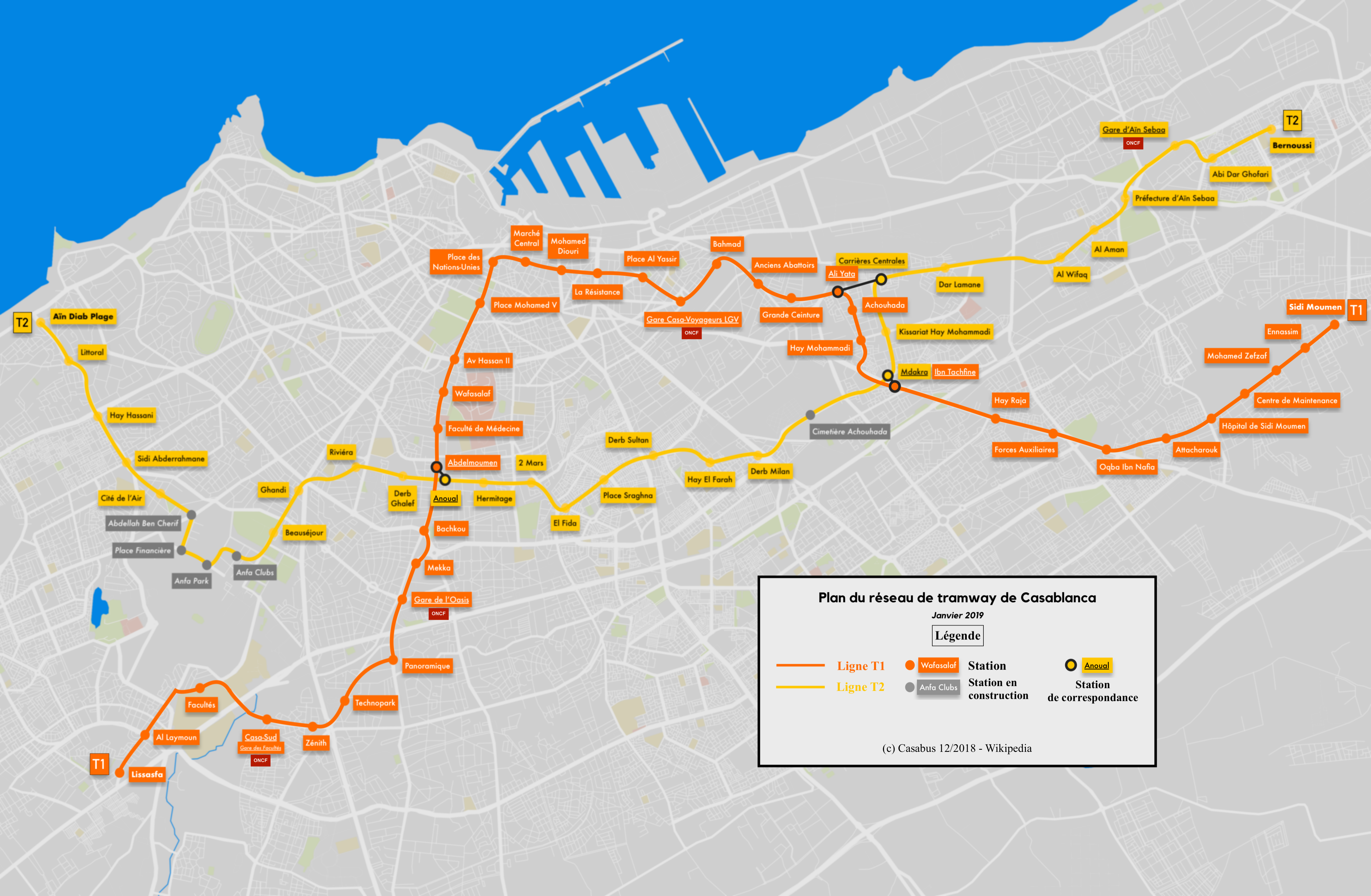
Français : Carte du réseau de tramway de Casablanca (Maroc). Janvier 2019 Deutsch: Topgraphische Karte des Straßenbahnnetzes von Casablanca (Marokko). Stand Januar 2019 |
| Date | |
| Source | Own work |
| Author | Casabus |
Licensing edit
I, the copyright holder of this work, hereby publish it under the following license:
This file is licensed under the Creative Commons Attribution-Share Alike 4.0 International license.
- You are free:
- to share – to copy, distribute and transmit the work
- to remix – to adapt the work
- Under the following conditions:
- attribution – You must give appropriate credit, provide a link to the license, and indicate if changes were made. You may do so in any reasonable manner, but not in any way that suggests the licensor endorses you or your use.
- share alike – If you remix, transform, or build upon the material, you must distribute your contributions under the same or compatible license as the original.
File history
Click on a date/time to view the file as it appeared at that time.
| Date/Time | Thumbnail | Dimensions | User | Comment | |
|---|---|---|---|---|---|
| current | 16:10, 24 January 2020 | | 5,200 × 3,400 (6.47 MB) | Bürgerentscheid (talk | contribs) | Reverted to version as of 21:06, 29 December 2018 (UTC). Schematical map now with different file name: File:CasablancaTram2019.png |
| 18:10, 20 January 2019 | 9,449 × 2,166 (942 KB) | Casabus (talk | contribs) | Carte du réseau de tram de Casablanca | ||
| 21:06, 29 December 2018 |  | 5,200 × 3,400 (6.47 MB) | Casabus (talk | contribs) | User created page with UploadWizard |
You cannot overwrite this file.
File usage on Commons
The following 13 pages use this file:
- User:Chumwa/OgreBot/Potential transport maps/2018 December 21-31
- User:Chumwa/OgreBot/Potential transport maps/2019 January 11-20
- User:Chumwa/OgreBot/Potential transport maps/2020 January 21-31
- User:Chumwa/OgreBot/Public transport information/2018 December 21-31
- User:Chumwa/OgreBot/Public transport information/2019 January 11-20
- User:Chumwa/OgreBot/Public transport information/2020 January 21-31
- User:Chumwa/OgreBot/Transport Maps/2018 December 21-31
- User:Chumwa/OgreBot/Transport Maps/2019 January 11-20
- User:Chumwa/OgreBot/Transport Maps/2020 January 21-31
- User:Chumwa/OgreBot/Travel and communication maps/2018 December 21-31
- User:Chumwa/OgreBot/Travel and communication maps/2019 January 11-20
- User:OgreBot/Watercraft/2018 December 29
- User:OgreBot/Watercraft/2019 January 20
File usage on other wikis
The following other wikis use this file:
- Usage on de.wikipedia.org
- Usage on es.wikipedia.org