File:CarteTopoDelftAltitude.jpg

Size of this preview: 797 × 599 pixels. Other resolutions: 319 × 240 pixels | 638 × 480 pixels | 871 × 655 pixels.
Original file (871 × 655 pixels, file size: 269 KB, MIME type: image/jpeg)
Captions
Captions
Add a one-line explanation of what this file represents
Summary
edit
| Description |
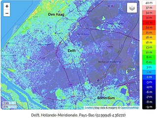
Français : Cette carte détaille le relief et l'altitude de la commune de Delft, ainsi que les villes environnantes dont Rotterdam et La Haye (Pays-Bas) |
| Date | |
| Source | https://fr-fr.topographic-map.com/maps/e5ua/Delft/ |
| Author | © les contributeurs d’OpenStreetMap / Leaflet |
Licensing
edit
This file is licensed under the Creative Commons Attribution-Share Alike 4.0 International license.
- You are free:
- to share – to copy, distribute and transmit the work
- to remix – to adapt the work
- Under the following conditions:
- attribution – You must give appropriate credit, provide a link to the license, and indicate if changes were made. You may do so in any reasonable manner, but not in any way that suggests the licensor endorses you or your use.
- share alike – If you remix, transform, or build upon the material, you must distribute your contributions under the same or compatible license as the original.
File history
Click on a date/time to view the file as it appeared at that time.
| Date/Time | Thumbnail | Dimensions | User | Comment | |
|---|---|---|---|---|---|
| current | 13:18, 18 April 2020 | | 871 × 655 (269 KB) | PBrieux (talk | contribs) | Uploaded a work by © les contributeurs d’OpenStreetMap / Leaflet from https://fr-fr.topographic-map.com/maps/e5ua/Delft/ with UploadWizard |
You cannot overwrite this file.
File usage on Commons
There are no pages that use this file.
File usage on other wikis
The following other wikis use this file:
- Usage on fr.wikipedia.org