File:Carte Parc Connemara.svg

Size of this PNG preview of this SVG file: 800 × 551 pixels. Other resolutions: 320 × 221 pixels | 640 × 441 pixels | 1,024 × 706 pixels | 1,280 × 882 pixels | 2,560 × 1,764 pixels | 1,457 × 1,004 pixels.
Original file (SVG file, nominally 1,457 × 1,004 pixels, file size: 2.06 MB)
Captions
Captions
Add a one-line explanation of what this file represents
Summary
edit
| Description |
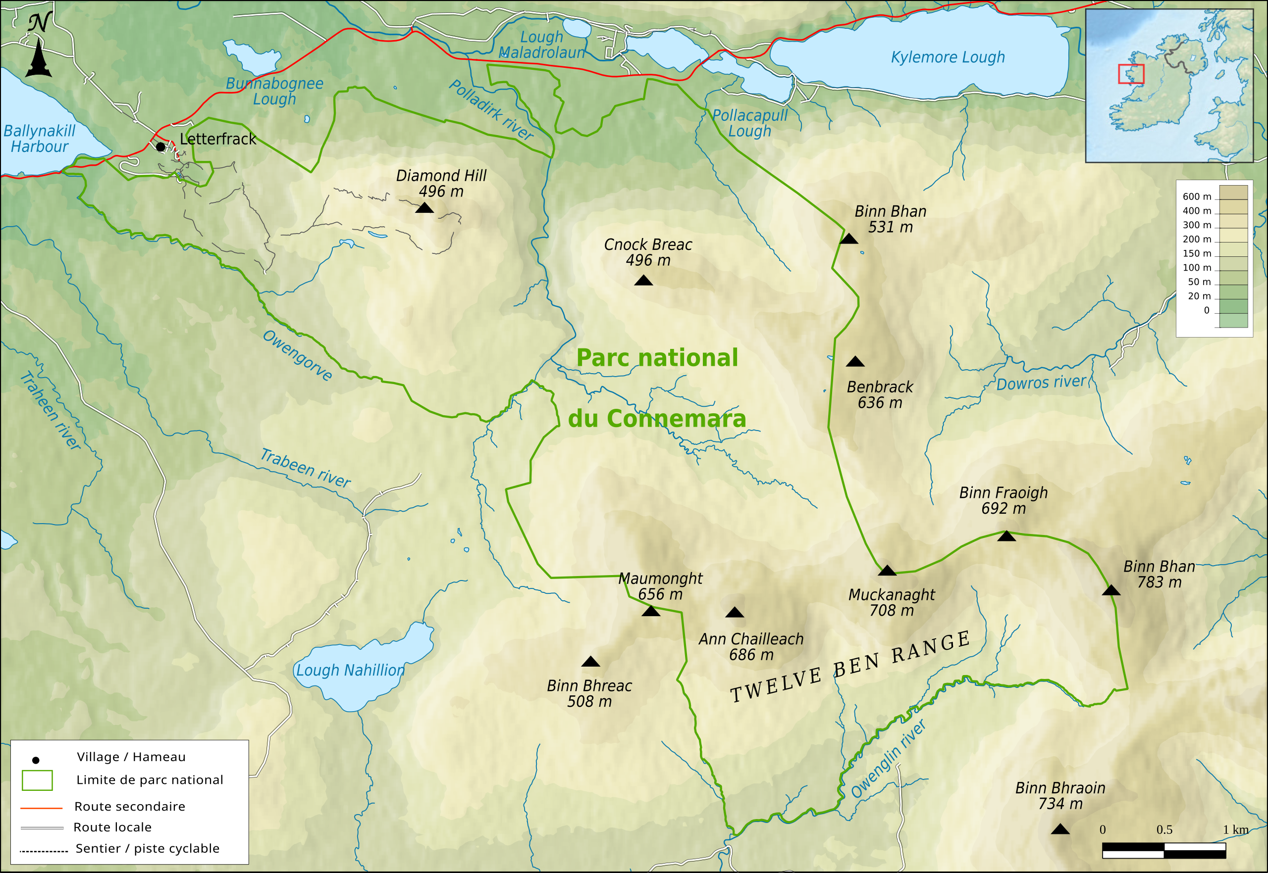
Français : Carte topographique du parc national du Connemara |
| Date | |
| Source |
Own work Relief : Aster Global Dem V2 Routes, hydrologie et limites administratives : Openstreetmap, EPA Geoportal Limites de parc national : NPWS |
| Author | Boldair |
Licensing
edit
I, the copyright holder of this work, hereby publish it under the following license:
This file is licensed under the Creative Commons Attribution-Share Alike 4.0 International license.
- You are free:
- to share – to copy, distribute and transmit the work
- to remix – to adapt the work
- Under the following conditions:
- attribution – You must give appropriate credit, provide a link to the license, and indicate if changes were made. You may do so in any reasonable manner, but not in any way that suggests the licensor endorses you or your use.
- share alike – If you remix, transform, or build upon the material, you must distribute your contributions under the same or compatible license as the original.
File history
Click on a date/time to view the file as it appeared at that time.
| Date/Time | Thumbnail | Dimensions | User | Comment | |
|---|---|---|---|---|---|
| current | 20:41, 19 March 2017 | | 1,457 × 1,004 (2.06 MB) | Boldair (talk | contribs) | rectifs |
| 08:09, 5 March 2017 |  | 1,457 × 1,004 (2.06 MB) | Boldair (talk | contribs) | rectif couleurs | |
| 07:46, 2 March 2017 |  | 1,457 × 1,004 (2.06 MB) | Boldair (talk | contribs) | correction barre alti | |
| 07:31, 2 March 2017 |  | 1,457 × 1,004 (2.06 MB) | Boldair (talk | contribs) | User created page with UploadWizard |
You cannot overwrite this file.
File usage on Commons
There are no pages that use this file.
File usage on other wikis
The following other wikis use this file:
- Usage on es.wikipedia.org
- Usage on fr.wikipedia.org
- Usage on nl.wikipedia.org