File:Carte de la Syrie FR.png
No higher resolution available.
Carte_de_la_Syrie_FR.png (328 × 352 pixels, file size: 11 KB, MIME type: image/png)
Captions
Captions
Add a one-line explanation of what this file represents
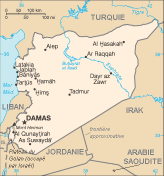
- (English) Subject: map of Syria, with French text.
- (français) Sujet : carte de la Syrie, avec texte en français.
- Other versions: Image:Sy-map.png (English text)
- Source: The World Factbook (CIA)
- License:
This image is in the public domain because it contains materials that originally came from the United States Central Intelligence Agency's World Factbook.
|
 |
File history
Click on a date/time to view the file as it appeared at that time.
| Date/Time | Thumbnail | Dimensions | User | Comment | |
|---|---|---|---|---|---|
| current | 12:44, 28 April 2006 | | 328 × 352 (11 KB) | Hégésippe Cormier (talk | contribs) | *(English) '''Subject:''' map of Syria, with French text. *(français) '''Sujet :''' carte de la Syrie, avec texte en français. *'''Other versions:''' Image:Sy-map.png (English t |
You cannot overwrite this file.
File usage on Commons
The following 5 pages use this file:
File usage on other wikis
The following other wikis use this file:
- Usage on ar.wikipedia.org
- Usage on azb.wikipedia.org
- Usage on fi.wikipedia.org
- Usage on fr.wikipedia.org
- Syrie
- Damas
- Liste de villes de Syrie
- Utilisateur:Ceedjee/Guerre israélo arabe de 1948
- Portail:Syrie
- Portail:Syrie/Géographie de la Syrie
- Guerre civile syrienne
- Utilisateur:Le Correcteur/Syrie
- Bec de canard (Syrie)
- Portail:Lacs et cours d'eau/Le saviez-vous ?
- Utilisateur:Hermes7979
- Discussion:Bec de canard (Syrie)
- Wikipédia:Le saviez-vous ?/Archives/2015
- Utilisateur:GhosterBot/Log/Archives/2015/mai
- Portail:Lacs et cours d'eau/Le saviez-vous ?/27
- Utilisateur:GhosterBot/BacASable/testStat/Visibilité des anecdotes (2015)
- Wikipédia:Statistiques des anecdotes de la page d'accueil/Visibilité des anecdotes (2015)/2015 05
- Wikipédia:Statistiques des anecdotes de la page d'accueil/Visibilité des anecdotes (2015)
- Usage on fr.wikinews.org
- Usage on mg.wikipedia.org