File:Carte des Îles d'Aran en Irlande.jpg
Size of this preview: 800 × 443 pixels. Other resolutions: 320 × 177 pixels | 640 × 354 pixels | 1,088 × 602 pixels.
Original file (1,088 × 602 pixels, file size: 177 KB, MIME type: image/jpeg)
Captions
Captions
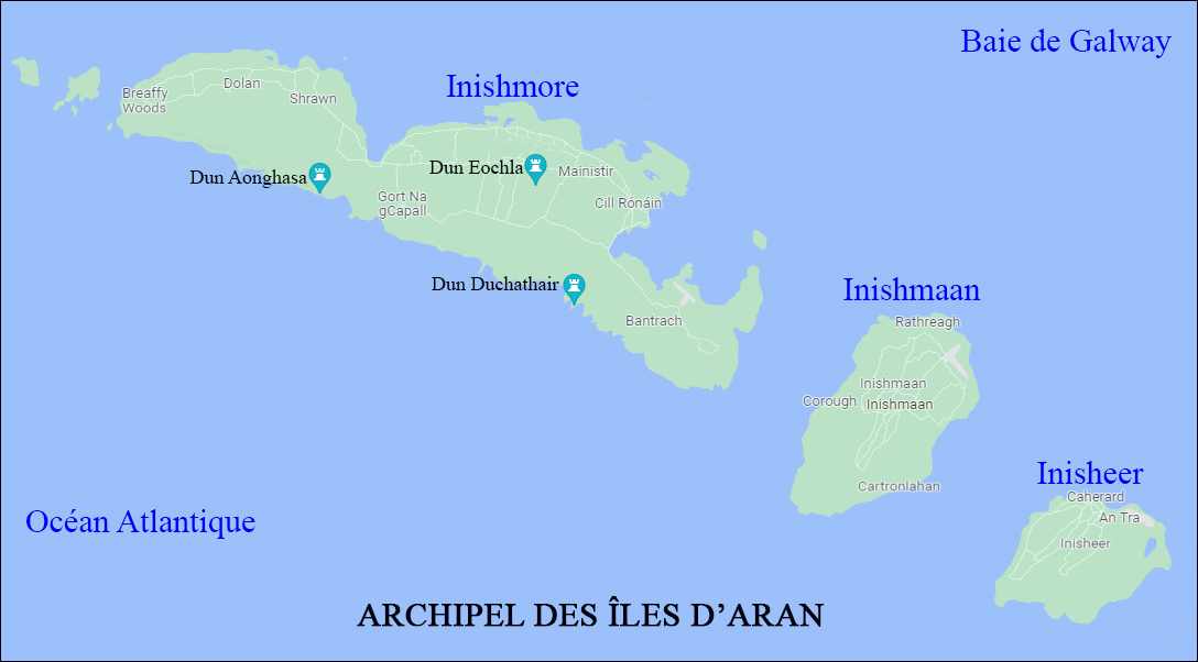
Map of the Aran islands in Ireland.
Summary
edit
| Description |
Français : Carte des Îles d'Aran, avec les principaux sites celtes. |
| Date | |
| Source | Wikimedia. Shuttle Radar Topography Mission: Ireland location map. svg: Nord-Nord-West. |
| Author | Nilfanion |
Cette photo déjà sur Wikimédia File:Shuttle Radar Topography Mission: Ireland location map. svg: Nord-Nord-West. , a été recadrée, éclaircie et nettoyée par moi, avant sa proposition de mise sur Wikimédia, pour l'adapter et illustrer mon article en cours de préparation sur le brouillon de Wikipédia.
Licensing
edit
This file is licensed under the Creative Commons Attribution-Share Alike 3.0 Unported license.
- You are free:
- to share – to copy, distribute and transmit the work
- to remix – to adapt the work
- Under the following conditions:
- attribution – You must give appropriate credit, provide a link to the license, and indicate if changes were made. You may do so in any reasonable manner, but not in any way that suggests the licensor endorses you or your use.
- share alike – If you remix, transform, or build upon the material, you must distribute your contributions under the same or compatible license as the original.
File history
Click on a date/time to view the file as it appeared at that time.
| Date/Time | Thumbnail | Dimensions | User | Comment | |
|---|---|---|---|---|---|
| current | 15:39, 23 June 2023 | | 1,088 × 602 (177 KB) | O Breizh ma bro (talk | contribs) | Uploaded a work by Nilfanion from Wikimedia. Shuttle Radar Topography Mission: Ireland location map. svg: Nord-Nord-West. with UploadWizard |
You cannot overwrite this file.
File usage on Commons
There are no pages that use this file.
File usage on other wikis
The following other wikis use this file:
- Usage on fr.wikipedia.org