File:Carte des Côtes de Malabar et de Coromandel (MAPS 81).jpg
Original file (7,140 × 5,596 pixels, file size: 7.97 MB, MIME type: image/jpeg)
Captions
Captions
|
This image was automatically transferred from the collections of the University of Washington. While certainly the majority of metadata in their database is correct, it is not necessarily written by individuals who are expert on the material they are describing. Such images often have incorrect dates, locations, or other information. If you can verify that this information is correct, or correct it if it isn't, please do so and remove this template. Also, if you are correcting information, please also let the library know so that they can update the metadata on their site. You can contact UW LIBRARIES MSCUA at photos |
Summary
edit| Title |
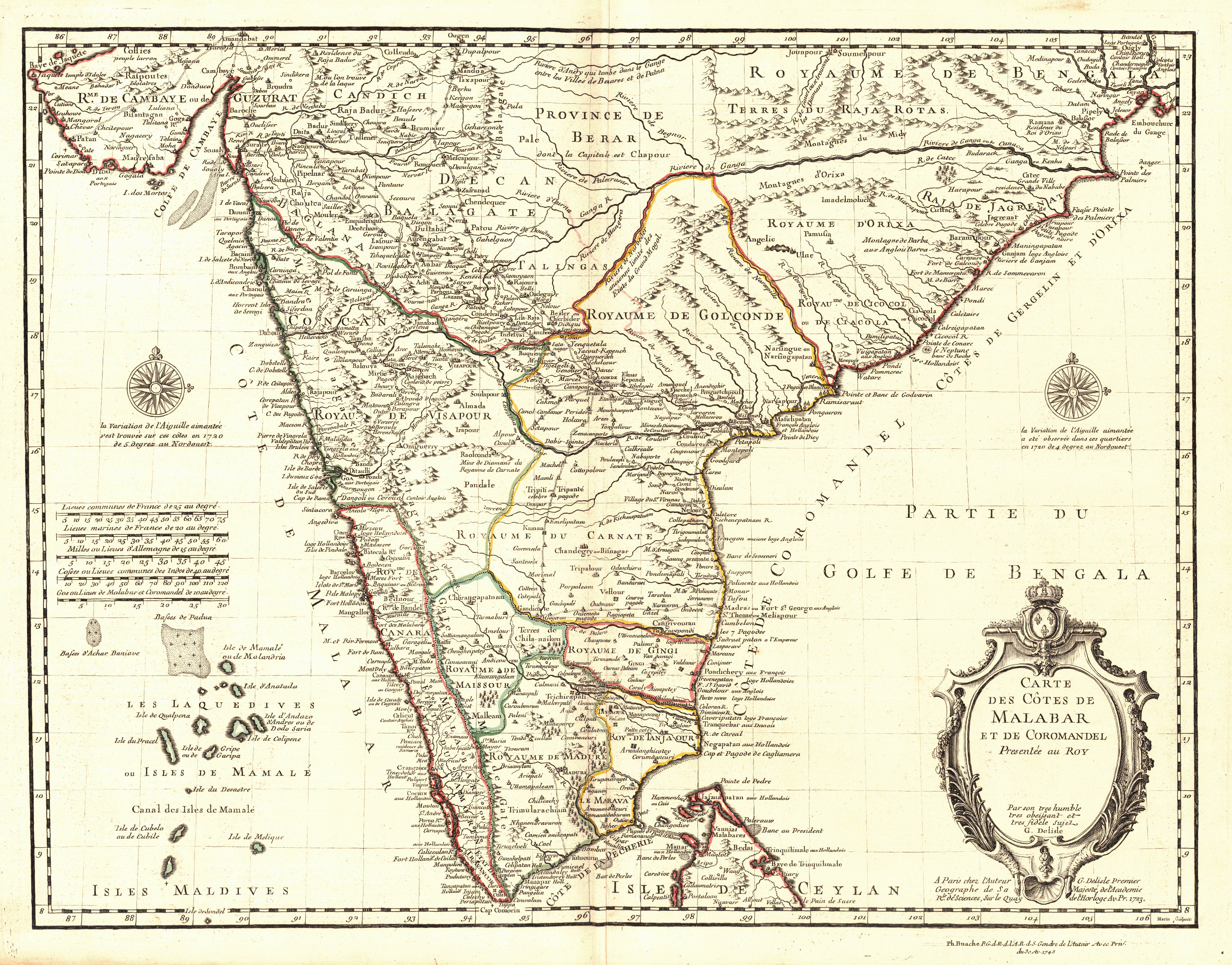
English: Carte des Côtes de Malabar et de Coromandel |
||||||||||||||||||||||||||||||||||||||||||
| Description |
English: Guillaume de L'Isle (1675-1726) was a cartographer and the Premier Geographer to the King in France beginning in 1718. His family played a significant part in the world of French cartography in the eighteenth century. At age 9, he drew his first map and at age 27 he became a member of the Académie Royale des Sciences. He studied under Jacques Cassini, acquiring knowledge in both mathematics and astronomy. Due to his academic background and his "critical approach to the maps of his predecessors," he became known as the first "scientific cartographer" (Moreland and Bannister, 132). Among his works are "Globe, map of the world and the four continents" (1700), "Atlas de Géographie" (1700-12), "Mississippi" (1701), "Carte du Mexique et de la Floride…" (c.a. 1703), "Carte de la Louisiane et du Mississippi" (1718) and posthumously, "Atlas Noveau" (1730 and later). Following his death, his widow took up the business with a partner, Philippe Buache (Tooley 395; Moreland and Bannister, 131-2). This particular map was first drawn by De L'Isle in 1723. It was later published by Philippe Buache in 1745 in "Atlas Noveau," almost twenty years after de L'Isle's death. Source(s): Moreland, Carl and David Bannister. "Antique Maps: A Collector's Handbook." New York: Longman Group, Ltd., 1983. Tooley, Ronald Vere. "Tooley's Dictionary of Mapmakers." Hertfordshire: Map Collector Publications Limited, 1979.Copper engraving handcolored with watercolor. Outline color. Relief shown pictorially. Printed in title cartouche in lower right corner: "Carte Des Cotes De Malabar Et De Coromandel Presentée au Roy Par son tres humble tres obeisant et tres fidele sujet G. Delisle." Printed beneath title cartouche: "A Paris chez l'Auteur G. Delisle Premier Geographe de Sa Majesté de l'Academie Rle. Des Sciences, Sur le Quay de l'Horloge Av. Pr. 1723." Printed in lower right corner outside border: "Ph. Buache P.G. d R d, l'A.R. d S. Gendre de l'Auteur Avec Priv. du 30 Av. 1745." Printed in center of left is a scale comparing French leagues, French sea leagues, German miles and Indian leagues. Written in brown ink in upper right corner: "No. 14." Shows southern India extending west from the Malabar Coast to the Coromandel Coast as well as part of northern Sri Lanka as "Isle de Ceylan," the Lakshadweep Islands in the southwest and part of the Maldives. The Ganges River, other major rivers and pictorial cities are depicted. Major trade routes and notes indicating colonies owned by the Dutch and British are included. Includes two compass roses on the left and right sides with the following inscription: "La Variation de l'Aiguille aimantéc s'est trouvée sur ces cotes en 1720 de 5 degrez au Nordouest." Scale: c.a. 1:4,000,000.
|
||||||||||||||||||||||||||||||||||||||||||
| Publisher | Buache, Philippe 1700-1773 | ||||||||||||||||||||||||||||||||||||||||||
| Digital ID Number | MAP136 | ||||||||||||||||||||||||||||||||||||||||||
| Condition | "No. 14" in ink in upper right corner. Has binder's guard and watermark. Light browning around edges. Centerfold backed with paper. Crease in lower right corner. | ||||||||||||||||||||||||||||||||||||||||||
| Date | |||||||||||||||||||||||||||||||||||||||||||
| Source |
English: World and Regional Maps Collection |
||||||||||||||||||||||||||||||||||||||||||
| Creator |
|
||||||||||||||||||||||||||||||||||||||||||
| Permission (Reusing this file) |
|
||||||||||||||||||||||||||||||||||||||||||
| Geotemporal data | |||||||||||||||||||||||||||||||||||||||||||
| Map location | India | ||||||||||||||||||||||||||||||||||||||||||
| Bounding box |
|
||||||||||||||||||||||||||||||||||||||||||
| Georeferencing | |||||||||||||||||||||||||||||||||||||||||||
| Bibliographic data | |||||||||||||||||||||||||||||||||||||||||||
| Publication |
"Atlas Noveau." Guillaume de L'Isle. Paris: Philippe Buache, 1745. |
||||||||||||||||||||||||||||||||||||||||||
| Place of publication | Paris | ||||||||||||||||||||||||||||||||||||||||||
| Archival data | |||||||||||||||||||||||||||||||||||||||||||
| Collection |
|
||||||||||||||||||||||||||||||||||||||||||
| Accession number | |||||||||||||||||||||||||||||||||||||||||||
| Dimensions | height: 44 cm (17.3 in); width: 56 cm (22 in) | ||||||||||||||||||||||||||||||||||||||||||

.jpg&action=edit§ion=1)
File history
Click on a date/time to view the file as it appeared at that time.
| Date/Time | Thumbnail | Dimensions | User | Comment | |
|---|---|---|---|---|---|
| current | 15:46, 26 June 2022 | | 7,140 × 5,596 (7.97 MB) | BMacZeroBot (talk | contribs) | Batch upload (Commons:Batch uploading/University of Washington Digital Collections) |
You cannot overwrite this file.
File usage on Commons
There are no pages that use this file.
.jpg&oldid=849223351)