File:Carte des domaines structuraux des Alpes occidentales.png

Size of this preview: 500 × 600 pixels. Other resolutions: 200 × 240 pixels | 400 × 480 pixels | 640 × 768 pixels | 853 × 1,024 pixels | 1,707 × 2,048 pixels | 5,000 × 6,000 pixels.
Original file (5,000 × 6,000 pixels, file size: 1.75 MB, MIME type: image/png)
Captions
Captions
Add a one-line explanation of what this file represents
Summary edit
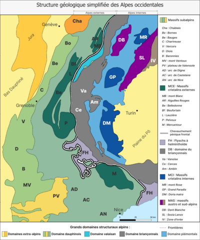
| Description |
Français : Carte représentant les domaines géologiques structurant les Alpes occidentales // Carte géolocalisée |
| Date | |
| Source |
Own work
• Assemblé et enrichi dans fr:QGis.
|
| Author | Poudou99 |
| Other versions |
|

Licensing edit
I, the copyright holder of this work, hereby publish it under the following license:
This file is licensed under the Creative Commons Attribution 4.0 International license.
- You are free:
- to share – to copy, distribute and transmit the work
- to remix – to adapt the work
- Under the following conditions:
- attribution – You must give appropriate credit, provide a link to the license, and indicate if changes were made. You may do so in any reasonable manner, but not in any way that suggests the licensor endorses you or your use.
File history
Click on a date/time to view the file as it appeared at that time.
| Date/Time | Thumbnail | Dimensions | User | Comment | |
|---|---|---|---|---|---|
| current | 23:06, 22 November 2023 | | 5,000 × 6,000 (1.75 MB) | Poudou99 (talk | contribs) | Grey color for ZB zone |
| 19:14, 17 November 2023 |  | 5,000 × 6,000 (2.24 MB) | Poudou99 (talk | contribs) | new version | |
| 01:31, 16 November 2023 |  | 5,000 × 6,000 (1.99 MB) | Poudou99 (talk | contribs) | Couleurs différentes pour les massifs DB, SL et IV | |
| 21:57, 13 November 2023 |  | 5,000 × 6,000 (1.91 MB) | Poudou99 (talk | contribs) | + lakes & rivers | |
| 21:20, 13 November 2023 |  | 5,000 × 6,000 (1.37 MB) | Poudou99 (talk | contribs) | best colors | |
| 21:42, 12 November 2023 |  | 5,000 × 6,000 (2.98 MB) | Poudou99 (talk | contribs) | Uploaded own work with UploadWizard |
You cannot overwrite this file.
File usage on Commons
The following page uses this file:
File usage on other wikis
The following other wikis use this file: