File:Carte le havre 1530.png

Size of this preview: 800 × 529 pixels. Other resolutions: 320 × 212 pixels | 640 × 423 pixels | 1,024 × 677 pixels | 1,280 × 846 pixels | 2,560 × 1,693 pixels | 4,756 × 3,145 pixels.
Original file (4,756 × 3,145 pixels, file size: 29.26 MB, MIME type: image/png)
Captions
Captions
Add a one-line explanation of what this file represents
Summary
edit
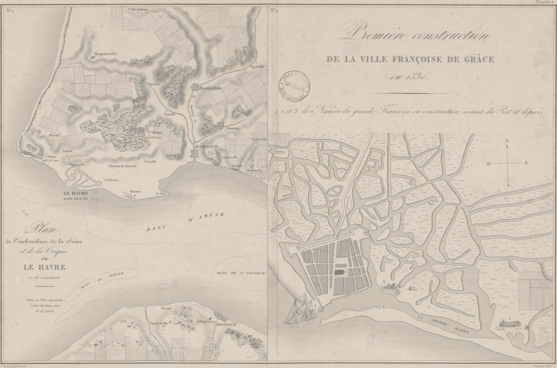
| Description |
Français : Plan du Havre en 1530.
English: Map of Le Havre in 1530. |
| Date | [1] |
| Source | Archives municipales de la ville du Havre [2] |
| Author | Pierre-François Frissard (drawing), Adam (engraving) |
| Other versions | cleaned version: File:Carte le havre 1530 nettoye.png; white background: File:Carte le havre 1530 fond blanc.png |
Licensing
edit
|
This work is in the public domain in its country of origin and other countries and areas where the copyright term is the author's life plus 100 years or fewer. | |
| This file has been identified as being free of known restrictions under copyright law, including all related and neighboring rights. | |
File history
Click on a date/time to view the file as it appeared at that time.
| Date/Time | Thumbnail | Dimensions | User | Comment | |
|---|---|---|---|---|---|
| current | 11:58, 25 March 2015 | | 4,756 × 3,145 (29.26 MB) | Cdang (talk | contribs) | {{Information |Description={{fr|1=Plan du Havre en 1530.}} {{en|1=Map of Le Havre in 1530.}} |Source=Archives municipales de la ville du Havre [http://avenio.ville-lehavre.fr/4DCGI/Web_DFPict/034/1Fi30/ILUMP28717] |Date=1530 |Author=Frissard |Permissio... |
You cannot overwrite this file.
File usage on Commons
There are no pages that use this file.