File:Carte que les Gnacsitares ont Dessine.jpg
Size of this preview: 799 × 329 pixels. Other resolutions: 320 × 132 pixels | 640 × 264 pixels | 1,024 × 422 pixels | 2,207 × 909 pixels.
Original file (2,207 × 909 pixels, file size: 1.46 MB, MIME type: image/jpeg)
Captions
Captions
Add a one-line explanation of what this file represents
Summary edit
| Description |
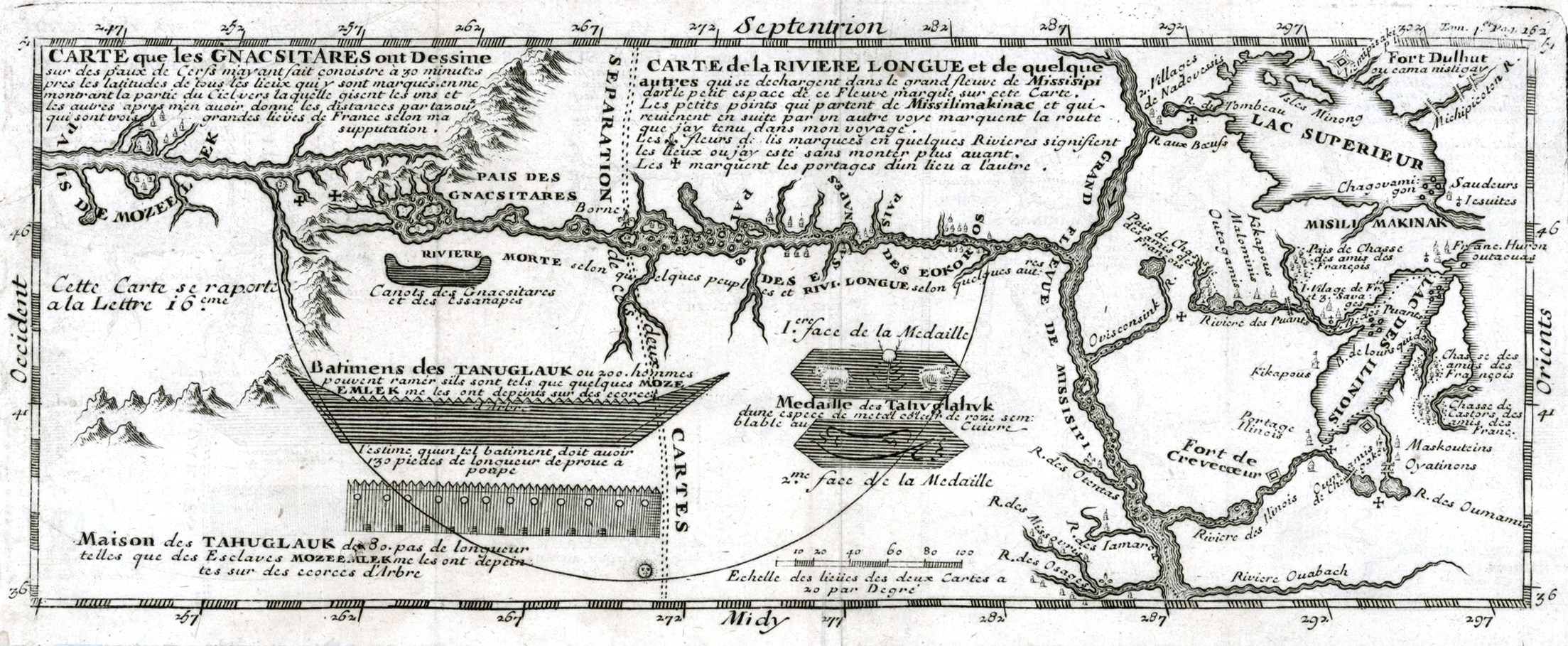
English: Map depicting Baron de Lahontan's west-east Long River (Riviere Longue), rising in distant western mountains and emptying into the upper Mississippi.
The map extends east to the Great Lakes to show Lac Superieur, and Lac de Illinois (Michigan), along with a number of the early French forts and fur trading outposts. Français : Carte que les Gnacsitares ont Dessine sur ... Carte de la Riviere Longue et de quelques Autres qui se Dechargent dans le Grand Fleuve Missisipi . . . |
| Date | |
| Source | raremaps.com - * |
| Author | Louis-Armand de Lom d'Arce, Baron de Lahontan |
Licensing edit
|
This work is in the public domain in its country of origin and other countries and areas where the copyright term is the author's life plus 70 years or fewer. This work is in the public domain in the United States because it was published (or registered with the U.S. Copyright Office) before January 1, 1929. | |
| This file has been identified as being free of known restrictions under copyright law, including all related and neighboring rights. | |
File history
Click on a date/time to view the file as it appeared at that time.
| Date/Time | Thumbnail | Dimensions | User | Comment | |
|---|---|---|---|---|---|
| current | 18:54, 17 January 2016 | 2,207 × 909 (1.46 MB) | Jeangagnon (talk | contribs) | crop | |
| 18:48, 17 January 2016 |  | 2,258 × 1,000 (2.46 MB) | Jeangagnon (talk | contribs) | User created page with UploadWizard |
You cannot overwrite this file.
File usage on Commons
There are no pages that use this file.
File usage on other wikis
The following other wikis use this file:
- Usage on de.wikipedia.org
- Usage on en.wikipedia.org