File:Cartogramme des élections fédérales canadiennes de 2021.svg

Size of this PNG preview of this SVG file: 800 × 365 pixels. Other resolutions: 320 × 146 pixels | 640 × 292 pixels | 1,024 × 468 pixels | 1,280 × 585 pixels | 2,560 × 1,169 pixels | 1,782 × 814 pixels.
Original file (SVG file, nominally 1,782 × 814 pixels, file size: 287 KB)
Captions
Captions
French-language cartogram of the 2021 Canadian federal election results using equal-area ridings
Summary edit
| Description |
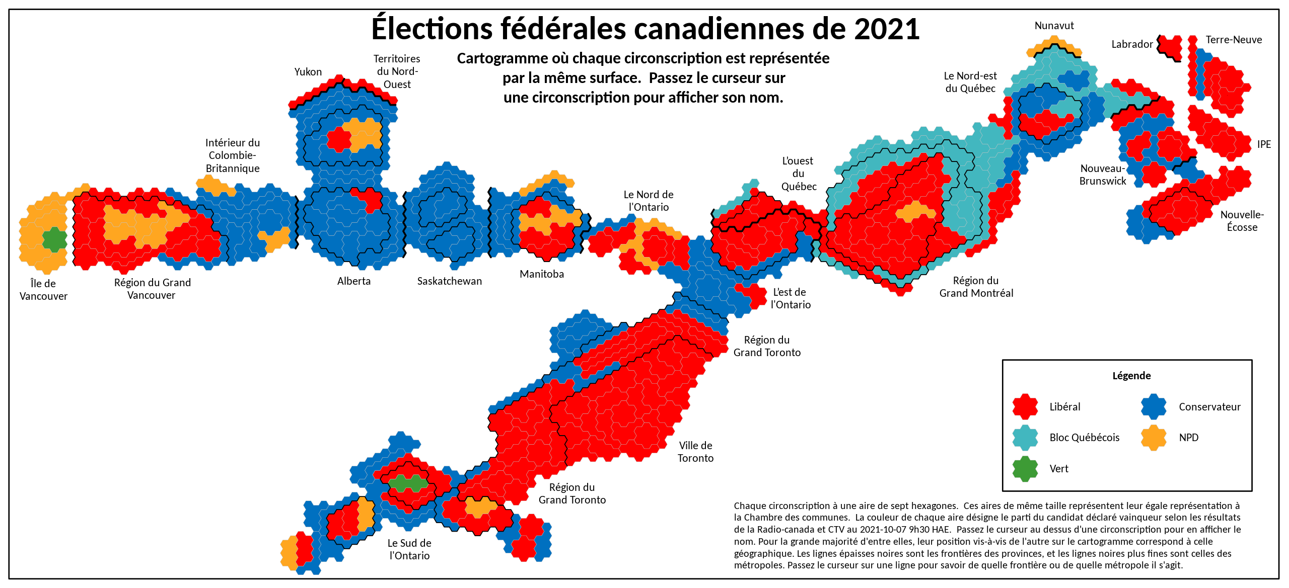
English: This is a cartogram of the 2021 Canadian federal election results. A cartogram is like a map, except that the areas used are not the geographical areas. In this case, each federal riding is of equal size, so each area represents one vote in the House of Commons.
Français : Cartogramme des élections fédérales canadiennes de 2021 où chaque circonscription est représentée par la même surface. Chaque circonscription à une aire de sept hexagones. Ces aires de même taille représentent leur égale représentation à la Chambre des communes. La couleur de chaque aire désigne le parti du candidat déclaré vainqueur selon les résultats de la Radio-canada et CTV au 2021-10-07 9h30 HAE. Passez le curseur au dessus d'une circonscription pour en afficher le nom. Pour la grande majorité d'entre elles, leur position vis-à-vis de l'autre sur le cartogramme correspond à celle géographique. Les lignes épaisses noires sont les frontières des provinces, et les lignes noires plus fines sont celles des métropoles. Passez le curseur sur une ligne pour savoir de quelle frontière ou de quelle métropole il s'agit. |
| Date | |
| Source | Own work |
| Author | Mark Gargul |
French-language version of Wikimedia Commons file Canadian_Federal_Election_Cartogram_2021.svg by the same author
Licensing edit
I, the copyright holder of this work, hereby publish it under the following license:
This file is licensed under the Creative Commons Attribution-Share Alike 4.0 International license.
- You are free:
- to share – to copy, distribute and transmit the work
- to remix – to adapt the work
- Under the following conditions:
- attribution – You must give appropriate credit, provide a link to the license, and indicate if changes were made. You may do so in any reasonable manner, but not in any way that suggests the licensor endorses you or your use.
- share alike – If you remix, transform, or build upon the material, you must distribute your contributions under the same or compatible license as the original.
File history
Click on a date/time to view the file as it appeared at that time.
| Date/Time | Thumbnail | Dimensions | User | Comment | |
|---|---|---|---|---|---|
| current | 19:56, 7 October 2021 | | 1,782 × 814 (287 KB) | JoeSchlabotnik (talk | contribs) | Uploaded own work with UploadWizard |
You cannot overwrite this file.
File usage on Commons
The following page uses this file:
File usage on other wikis
The following other wikis use this file:
- Usage on fr.wikipedia.org