File:Cartouche in a Latvia map by the Russian Academy.jpg

Size of this preview: 400 × 600 pixels. Other resolutions: 160 × 240 pixels | 320 × 480 pixels | 512 × 768 pixels | 683 × 1,024 pixels | 1,597 × 2,395 pixels.
Original file (1,597 × 2,395 pixels, file size: 612 KB, MIME type: image/jpeg)
Captions
Captions
Add a one-line explanation of what this file represents
| Warning | The original file is very high-resolution. It might not load properly or could cause your browser to freeze when opened at full size. |
|---|
Summary
edit| Description |
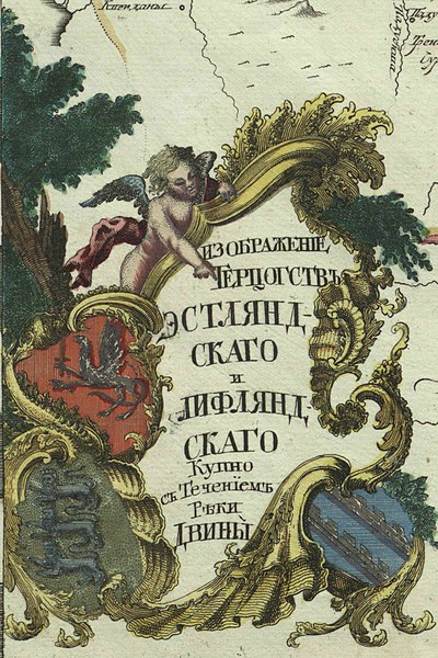
Русский: Первый официальный атлас Российской империи (1745). Карта герцогств Эстляндского и Лифляндского, вместе с течением реки Двины. Оригинальная карта гравирована на меди и раскрашена вручную акварелью.
English: First official geographic atlas of the Russian Empire (1745). Map of Estland and Livland duchies, include Dvina river. Hand-coloured copper engraving. |
| Date | |
| Source |
Русский: Атлас Российский (1745)
English: Geographic atlas of the Russian Empire (1745) |
| Author | РАН (Russian Academy of Science) |
| Other versions |
|
.jpg)
.jpg)
.jpg)
.jpg)
.jpg)
Licensing
edit
|
This work is in the public domain in its country of origin and other countries and areas where the copyright term is the author's life plus 100 years or fewer. | |
| This file has been identified as being free of known restrictions under copyright law, including all related and neighboring rights. | |
File history
Click on a date/time to view the file as it appeared at that time.
| Date/Time | Thumbnail | Dimensions | User | Comment | |
|---|---|---|---|---|---|
| current | 14:36, 22 December 2022 | | 1,597 × 2,395 (612 KB) | Enyavar (talk | contribs) | File:Russian Empire 1745 (Map III HQ).jpg cropped 83 % horizontally, 71 % vertically using CropTool with precise mode. |
You cannot overwrite this file.
File usage on Commons
The following page uses this file: