File:Cartouche in a Negroland map by Bowen.jpg

Size of this preview: 800 × 439 pixels. Other resolutions: 320 × 176 pixels | 640 × 352 pixels | 1,024 × 562 pixels | 1,280 × 703 pixels | 2,671 × 1,467 pixels.
Original file (2,671 × 1,467 pixels, file size: 1.12 MB, MIME type: image/jpeg)
Captions
Captions
Add a one-line explanation of what this file represents
Summary
edit| Description |
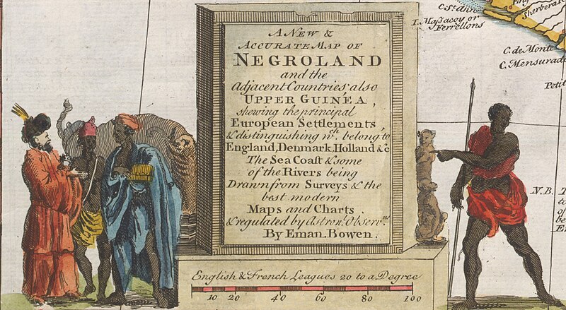
Nederlands: A new and accurate map of Negroland and the Adjacent Countries; also Upper Guinea, showing the principal European Settlements, & distinguishing wch. belongi to England, Denmark, Holland &c the sea coaſt & some of the rivers being drawn from Surveys & the best modern maps and charts |
| Date | |
| Source | https://purl.stanford.edu/mn533bd1896 |
| Author | Bowen, Emanuel, -1767 |
| Other versions |

Licensing
edit
|
This work is in the public domain in its country of origin and other countries and areas where the copyright term is the author's life plus 70 years or fewer. This work is in the public domain in the United States because it was published (or registered with the U.S. Copyright Office) before January 1, 1929. | |
| This file has been identified as being free of known restrictions under copyright law, including all related and neighboring rights. | |
File history
Click on a date/time to view the file as it appeared at that time.
| Date/Time | Thumbnail | Dimensions | User | Comment | |
|---|---|---|---|---|---|
| current | 14:34, 17 December 2022 | | 2,671 × 1,467 (1.12 MB) | Enyavar (talk | contribs) | File:A new and accurate map of Negroland and the Adjacent Countries.jpg cropped 70 % horizontally, 81 % vertically using CropTool with precise mode. |
You cannot overwrite this file.
File usage on Commons
The following page uses this file: