File:Cartouche on a Europe map by Dezauche.jpg

Size of this preview: 331 × 600 pixels. Other resolutions: 132 × 240 pixels | 265 × 480 pixels | 684 × 1,239 pixels.
Original file (684 × 1,239 pixels, file size: 427 KB, MIME type: image/jpeg)
Captions
Captions
Add a one-line explanation of what this file represents
Summary
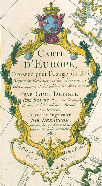
edit| Map of Europe
( |
||||||||||||||||||||||||
|---|---|---|---|---|---|---|---|---|---|---|---|---|---|---|---|---|---|---|---|---|---|---|---|---|
| Artist |
Jean-Claude Dezauche (ca. 1750 - 1824) – Draftsman (French) Details on Google Art Project |
|||||||||||||||||||||||
| Title |
Français : Carte d’Europe, Dressée pour l’Usage du Roi D’apres les Itinèraires et les Observations Astronomiques de l’Académie R.le des Sciences par Guil. Delisle Phil. Buache, Premiers Géographes du Roi et de l’Académie Royale des Sciences. Revue et Augmentée par Dezauche, Géographe et Successeur des S.rs Delisle et Buache. 1789 A Paris Chez l’Auteur Rue des Noyers. Avec privilege du Roi. Map of Europe |
|||||||||||||||||||||||
| Object type | ||||||||||||||||||||||||
| Date | 1789 | |||||||||||||||||||||||
| Dimensions | height: 500 mm (19.68 in); width: 620 mm (24.40 in) | |||||||||||||||||||||||
| Collection |
|
|||||||||||||||||||||||
| Accession number |
Wil.5626 |
|||||||||||||||||||||||
| Object history |
English: Bought by the Wilanów Palace Museum in 2005. |
|||||||||||||||||||||||
| Source/Photographer | PwFWpU3nzxZLQA at Google Cultural Institute maximum zoom level | |||||||||||||||||||||||
| Other versions | ||||||||||||||||||||||||


Licensing
edit
|
This is a faithful photographic reproduction of a two-dimensional, public domain work of art. The work of art itself is in the public domain for the following reason:
The official position taken by the Wikimedia Foundation is that "faithful reproductions of two-dimensional public domain works of art are public domain".
This photographic reproduction is therefore also considered to be in the public domain in the United States. In other jurisdictions, re-use of this content may be restricted; see Reuse of PD-Art photographs for details. | ||||
File history
Click on a date/time to view the file as it appeared at that time.
| Date/Time | Thumbnail | Dimensions | User | Comment | |
|---|---|---|---|---|---|
| current | 17:20, 2 December 2022 | | 684 × 1,239 (427 KB) | Enyavar (talk | contribs) | File:Jean-Claude Dezauche - Map of Europe - Google Art Project.jpg cropped 83 % horizontally, 62 % vertically, rotated -0.4° using CropTool with precise mode. |
You cannot overwrite this file.
File usage on Commons
The following 2 pages use this file: