File:Cassini Lourdes-Est.PNG
Size of this preview: 800 × 557 pixels. Other resolutions: 320 × 223 pixels | 640 × 446 pixels | 879 × 612 pixels.
Original file (879 × 612 pixels, file size: 1.25 MB, MIME type: image/png)
Captions
Captions
Add a one-line explanation of what this file represents
Summary
edit
| Description |
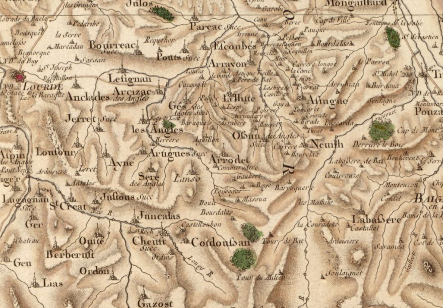
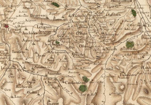
Français : Extrait de la carte de Cassini (Collection « Hauslab-Liechtenstein ») correspondant au territoire du canton de Lourdes-Est et à l'ouest de celui de Bagnères de Bigorre. . |
| Date | circa 1780 |
| Source | Carte de Cassini |
| Author | Cassini |
Licensing
edit
I, the copyright holder of this work, hereby publish it under the following licenses:

|
Permission is granted to copy, distribute and/or modify this document under the terms of the GNU Free Documentation License, Version 1.2 or any later version published by the Free Software Foundation; with no Invariant Sections, no Front-Cover Texts, and no Back-Cover Texts. A copy of the license is included in the section entitled GNU Free Documentation License. |
This file is licensed under the Creative Commons Attribution-Share Alike 4.0 International, 3.0 Unported, 2.5 Generic, 2.0 Generic and 1.0 Generic license.
- You are free:
- to share – to copy, distribute and transmit the work
- to remix – to adapt the work
- Under the following conditions:
- attribution – You must give appropriate credit, provide a link to the license, and indicate if changes were made. You may do so in any reasonable manner, but not in any way that suggests the licensor endorses you or your use.
- share alike – If you remix, transform, or build upon the material, you must distribute your contributions under the same or compatible license as the original.
You may select the license of your choice.
File history
Click on a date/time to view the file as it appeared at that time.
| Date/Time | Thumbnail | Dimensions | User | Comment | |
|---|---|---|---|---|---|
| current | 22:41, 28 December 2009 | | 879 × 612 (1.25 MB) | Darreenvt (talk | contribs) | {{Information |Description={{fr|1=Extrait de la carte de Cassini (Collection « Hauslab-Liechtenstein ») correspondant au territoire du canton de Lourdes-Est.}} |Source=Carte de Cassini |Author=Cassini |Date=Vers 1780 |Permission= |other_versions= }} [[ |
You cannot overwrite this file.
File usage on Commons
There are no pages that use this file.
File usage on other wikis
The following other wikis use this file:
- Usage on fr.wikipedia.org
- Les Angles (Hautes-Pyrénées)
- Arcizac-ez-Angles
- Arrayou-Lahitte
- Arrodets-ez-Angles
- Artigues (Hautes-Pyrénées)
- Cheust
- Escoubès-Pouts
- Gazost
- Ger (Hautes-Pyrénées)
- Geu
- Gez-ez-Angles
- Jarret (Hautes-Pyrénées)
- Juncalas
- Lugagnan
- Neuilh
- Ossun-ez-Angles
- Ourdis-Cotdoussan
- Ourdon
- Ousté
- Saint-Créac (Hautes-Pyrénées)
- Sère-Lanso
- Canton de Lourdes-Est
- Vallée de Castelloubon
- Usage on la.wikipedia.org
- Usage on oc.wikipedia.org
- Usage on pt.wikipedia.org