File:Catalonia-regions-map.svg

Size of this PNG preview of this SVG file: 700 × 596 pixels. Other resolutions: 282 × 240 pixels | 564 × 480 pixels | 902 × 768 pixels | 1,203 × 1,024 pixels | 2,405 × 2,048 pixels.
Original file (SVG file, nominally 700 × 596 pixels, file size: 404 KB)
Captions
Captions
Add a one-line explanation of what this file represents
Summary
edit
| Description |
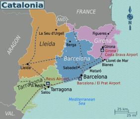
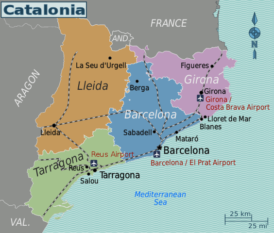
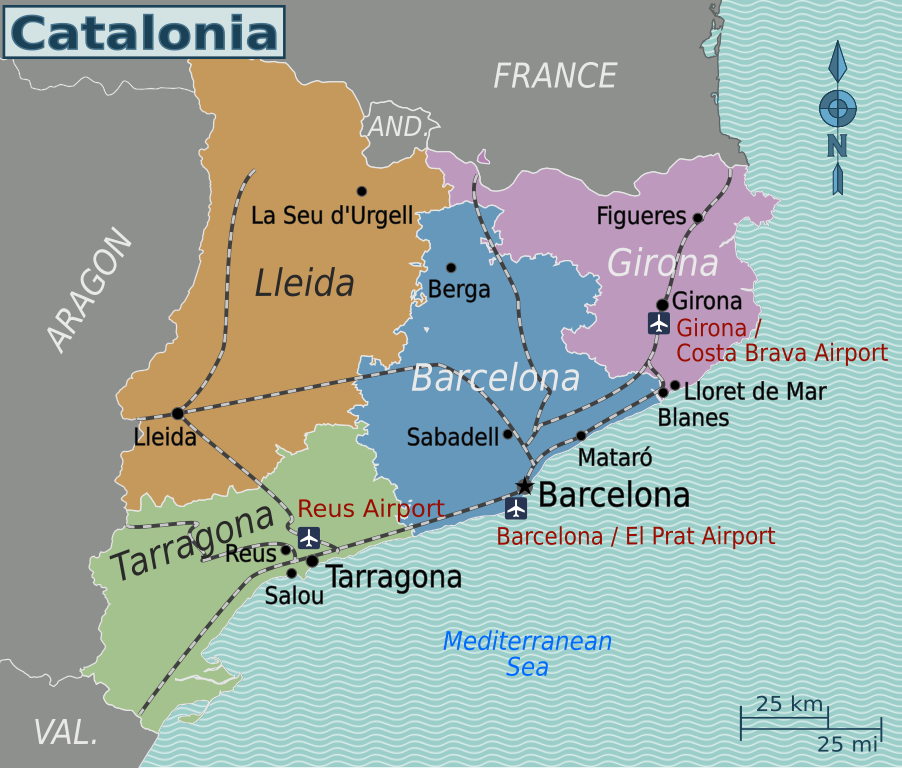
Map of Catalonia (SVG). |
| Date | |
| Source | Own work based on Catalonia location map.svg by HansenBCN. |
| Author | Globe-trotter |
| Other versions | Dutch, English. |
.png)
Licensing
edit
This file is licensed under the Creative Commons Attribution-Share Alike 3.0 Unported license.
- You are free:
- to share – to copy, distribute and transmit the work
- to remix – to adapt the work
- Under the following conditions:
- attribution – You must give appropriate credit, provide a link to the license, and indicate if changes were made. You may do so in any reasonable manner, but not in any way that suggests the licensor endorses you or your use.
- share alike – If you remix, transform, or build upon the material, you must distribute your contributions under the same or compatible license as the original.
Original upload log
edit
| This file was imported from Wikivoyage WTS. |
The original description page was here. All following user names refer to wts.wikivoyage-old.
- 2011-10-12 20:45 (WT-shared) Globe-trotter[dead link] 786×596 (386019 bytes) {{Imagecredit|credit=Globe-trotter, based on [http://commons.wikimedia.org/wiki/File:Catalonia_location_map.svg Catalonia_location_map.svg] (Import from wikitravel.org/shared)
- 2012-11-06 00:49 Globe-trotter[dead link] 786×596 (386605 bytes) improved somewhat
File history
Click on a date/time to view the file as it appeared at that time.
| Date/Time | Thumbnail | Dimensions | User | Comment | |
|---|---|---|---|---|---|
| current | 06:20, 6 December 2020 | | 700 × 596 (404 KB) | Shaundd (talk | contribs) | improve readability - larger font, increase contrast between font colour and background colour, reposition some labels |
| 10:43, 11 December 2013 |  | 786 × 596 (392 KB) | Eloi.sanmartin (talk | contribs) | Hide nl wich was overlaping en | |
| 10:42, 11 December 2013 |  | 786 × 596 (392 KB) | Eloi.sanmartin (talk | contribs) | Translations corrected | |
| 10:27, 11 December 2013 |  | 786 × 596 (390 KB) | Eloi.sanmartin (talk | contribs) | Airport name font correction | |
| 10:18, 11 December 2013 |  | 786 × 596 (390 KB) | Eloi.sanmartin (talk | contribs) | Airport name correction | |
| 10:16, 11 December 2013 |  | 786 × 596 (390 KB) | Eloi.sanmartin (talk | contribs) | Add rails and airports | |
| 21:21, 19 November 2012 |  | 786 × 596 (378 KB) | OgreBot (talk | contribs) | (BOT): Reverting to most recent version before archival | |
| 21:21, 19 November 2012 |  | 786 × 596 (377 KB) | OgreBot (talk | contribs) | (BOT): Uploading old version of file from wts.wikivoyage-old; originally uploaded on 2011-10-12 20:45:55 by (WT-shared) Globe-trotter | |
| 23:05, 17 November 2012 |  | 786 × 596 (378 KB) | MGA73bot2 (talk | contribs) | {{BotMoveToCommons|wts.oldwikivoyage|year={{subst:CURRENTYEAR}}|month={{subst:CURRENTMONTHNAME}}|day={{subst:CURRENTDAY}}}} == {{int:filedesc}} == {{Information |description=Map of Catalonia (SVG). * Map of: Catalonia¤ |date=October 12, 2011 |source={... |
You cannot overwrite this file.
File usage on Commons
The following 2 pages use this file:
File usage on other wikis
The following other wikis use this file: