File:Catalonia location map 2023 vegueries no counties.svg

Size of this PNG preview of this SVG file: 668 × 600 pixels. Other resolutions: 267 × 240 pixels | 535 × 480 pixels | 856 × 768 pixels | 1,141 × 1,024 pixels | 2,281 × 2,048 pixels | 2,786 × 2,501 pixels.
Original file (SVG file, nominally 2,786 × 2,501 pixels, file size: 252 KB)
Captions
Captions
Add a one-line explanation of what this file represents
Summary
edit
| Description |
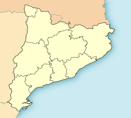
English: Location map of Catalonia. Equirectangular projection, N/S stretched 130%. Map geographic limits: * N: 42.99° N * S: 40.405° N * W: 0.55° O * E: 4.02° O. The division includes the vegueries, following the vegueries law of July 2010, updated in 2017. This map only includes the vegueries, with no county borders. |
| Date | |
| Source | Catalonia location map 2023 vegueries.svg |
| Author | Luna Caoimhe |
Licensing
edit
I, the copyright holder of this work, hereby publish it under the following license:
| This file is made available under the Creative Commons CC0 1.0 Universal Public Domain Dedication. | |
| The person who associated a work with this deed has dedicated the work to the public domain by waiving all of their rights to the work worldwide under copyright law, including all related and neighboring rights, to the extent allowed by law. You can copy, modify, distribute and perform the work, even for commercial purposes, all without asking permission.
|
File history
Click on a date/time to view the file as it appeared at that time.
| Date/Time | Thumbnail | Dimensions | User | Comment | |
|---|---|---|---|---|---|
| current | 17:57, 17 April 2024 | | 2,786 × 2,501 (252 KB) | Luna Caoimhe (talk | contribs) | Uploaded own work with UploadWizard |
You cannot overwrite this file.
File usage on Commons
The following page uses this file: