File:Caucasus-political-ru.svg

Size of this PNG preview of this SVG file: 632 × 599 pixels. Other resolutions: 253 × 240 pixels | 506 × 480 pixels | 810 × 768 pixels | 1,080 × 1,024 pixels | 2,159 × 2,048 pixels | 972 × 922 pixels.
Original file (SVG file, nominally 972 × 922 pixels, file size: 371 KB)
Captions
Captions
Add a one-line explanation of what this file represents
Summary edit
| Description |
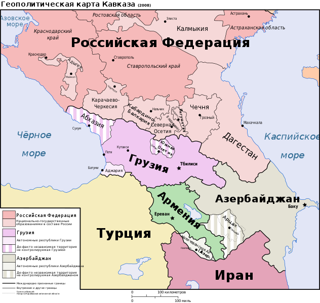
English: Geopolitical map of the Caucasus Region. Русский: Геополитическая карта Кавказа. Українська: Геополітична мапа Кавказу, (написи російською мовою). Абхазія та Південна Осетія відмічені штрихуванням, бо анексовані Росією, не зважаючи на рішення РБ ООН і реакцію міжнародної спільноти. |
||||||||
| Date | 02/09/08 | ||||||||
| Source |
English: Largest part of the borders based on Image:Caucasus-ethnic en.svg by User:Pmx, a vectorization of this CIA map. Former (autonomous oblast) and current (de facto independent republic) borders of Nagorno-Karabakh based on Location_Nagorno-Karabakh_en.png. North coast of Turkey based on Map_of_Turkey_(2007).gif. |
||||||||
| Author | Hayk | ||||||||
| Permission (Reusing this file) |
Hayk, the copyright holder of this work, hereby publishes it under the following licenses:
This file is licensed under the Creative Commons Attribution 2.5 Generic license. Attribution: Hayk
You may select the license of your choice. |
||||||||
| Other versions |
This map is a translation of Image:Caucasus-political nl.svg
[]
|


.png)


.gif)

|
This SVG file contains embedded text that can be translated into your language, using any capable SVG editor, text editor or the SVG Translate tool. For more information see: About translating SVG files. |
This W3C-unspecified vector image was created with Inkscape .
File history
Click on a date/time to view the file as it appeared at that time.
| Date/Time | Thumbnail | Dimensions | User | Comment | |
|---|---|---|---|---|---|
| current | 15:31, 20 January 2020 | | 972 × 922 (371 KB) | Takhirgeran Umar (talk | contribs) | clarification |
| 05:03, 27 April 2018 |  | 972 × 922 (370 KB) | Kentronhayastan (talk | contribs) | Updated "Nagorno-Karabakh" to "Artsakh," the new official name of the self-proclaimed republic. | |
| 12:59, 12 June 2011 |  | 972 × 922 (370 KB) | Hayk (talk | contribs) | == {{int:filedesc}} == {{Information |Description={{Multilingual description|en=Geopolitical map of the Caucasus Region.|ru=Геополитическая карта Кавказа.}} |Source={{en|Largest part of the |
You cannot overwrite this file.
File usage on Commons
The following 20 pages use this file:
- File:Caucasus-political-fr.svg
- File:Caucasus-political-krc.svg
- File:Caucasus-political-ru.svg
- File:Caucasus-political-tr.svg
- File:Caucasus-political (hy).png
- File:Caucasus-political Fa.svg
- File:Caucasus-political ca.svg
- File:Caucasus-political cs.svg
- File:Caucasus-political de.svg
- File:Caucasus-political en.svg
- File:Caucasus-political es.svg
- File:Caucasus-political ja.svg
- File:Caucasus-political mk.svg
- File:Caucasus-political mzn.svg
- File:Caucasus-political nl.svg
- File:Caucasus-political pl.svg
- File:Caucasus-political pt.svg
- File:Caucasus-political vi.svg
- File:Kaukasian geopoliittinen kartta.svg
- Template:Other versions/Caucasus-political
File usage on other wikis
The following other wikis use this file:
- Usage on ady.wikipedia.org
- Usage on kbd.wikipedia.org
- Usage on os.wikipedia.org
- Usage on ru.wikipedia.org
- Usage on sah.wikipedia.org
- Usage on tt.wikipedia.org
- Usage on uk.wikipedia.org