File:Caucasus 1530 map de.png

Size of this preview: 771 × 599 pixels. Other resolutions: 309 × 240 pixels | 618 × 480 pixels | 988 × 768 pixels | 1,280 × 995 pixels | 2,560 × 1,990 pixels | 3,000 × 2,332 pixels.
Original file (3,000 × 2,332 pixels, file size: 3.55 MB, MIME type: image/png)
Captions
Captions
Add a one-line explanation of what this file represents
Summary edit
| Description |
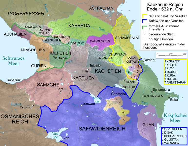
English: Map of Caucasus Region 1530 in German.
Deutsch: Kaukasus-Region Anfang 1530 n. Chr. Quellen sind:
.
|
| Date | |
| Source | Own work, derivate of File:Caucasus_topographic_map-fr.svg |
| Author |
|
| Other versions |
 |
Licensing edit
I, the copyright holder of this work, hereby publish it under the following licenses:

|
Permission is granted to copy, distribute and/or modify this document under the terms of the GNU Free Documentation License, Version 1.2 or any later version published by the Free Software Foundation; with no Invariant Sections, no Front-Cover Texts, and no Back-Cover Texts. A copy of the license is included in the section entitled GNU Free Documentation License. |
This file is licensed under the Creative Commons Attribution-Share Alike 3.0 Unported, 2.5 Generic, 2.0 Generic and 1.0 Generic license.
- You are free:
- to share – to copy, distribute and transmit the work
- to remix – to adapt the work
- Under the following conditions:
- attribution – You must give appropriate credit, provide a link to the license, and indicate if changes were made. You may do so in any reasonable manner, but not in any way that suggests the licensor endorses you or your use.
- share alike – If you remix, transform, or build upon the material, you must distribute your contributions under the same or compatible license as the original.
You may select the license of your choice.
File history
Click on a date/time to view the file as it appeared at that time.
| Date/Time | Thumbnail | Dimensions | User | Comment | |
|---|---|---|---|---|---|
| current | 08:50, 12 April 2020 | | 3,000 × 2,332 (3.55 MB) | Don-kun (talk | contribs) | some corrections after further inquiry |
| 18:25, 9 September 2014 |  | 2,990 × 2,324 (3.69 MB) | Don-kun (talk | contribs) | correction according Hewsen, Armenia: a historical atlas | |
| 19:09, 6 May 2014 |  | 3,000 × 2,332 (3.68 MB) | Don-kun (talk | contribs) | small corrections + Lasistan was part of Samzche until 1535 | |
| 10:56, 23 April 2014 |  | 3,000 × 2,332 (3.69 MB) | Don-kun (talk | contribs) | more corrections according to discussion | |
| 19:30, 14 April 2014 |  | 1,155 × 898 (1.02 MB) | Don-kun (talk | contribs) | corrections according this discussion https://de.wikipedia.org/wiki/Benutzer_Diskussion:Don-kun/Kartenserie_Kaukasus | |
| 18:56, 8 March 2014 |  | 1,155 × 898 (1,014 KB) | Don-kun (talk | contribs) | {{Information |Description ={{en|1=Map of Caucasus Region 1530 in German.}} {{de|1=Kaukasus-Region Anfang 1530 n. Chr. Quellen sind: * http://www.euratlas.net/history/europe/1500/index.html * http://www.armenica.org/cgi-bin/armenica.cgi?178711717323... |
You cannot overwrite this file.
File usage on Commons
The following page uses this file:
File usage on other wikis
The following other wikis use this file:
- Usage on als.wikipedia.org
- Usage on ar.wikipedia.org
- Usage on az.wikipedia.org
- Usage on de.wikipedia.org
- Usage on en.wikipedia.org
- Usage on frr.wikipedia.org
- Usage on lt.wikipedia.org
- Usage on ru.wikipedia.org
- Usage on tr.wikipedia.org
- Usage on www.wikidata.org