File:Caucasus regions map.png

Size of this preview: 743 × 600 pixels. Other resolutions: 298 × 240 pixels | 595 × 480 pixels | 952 × 768 pixels | 1,269 × 1,024 pixels | 2,000 × 1,614 pixels.
Original file (2,000 × 1,614 pixels, file size: 685 KB, MIME type: image/png)
Captions
Captions
Add a one-line explanation of what this file represents
Summary
edit
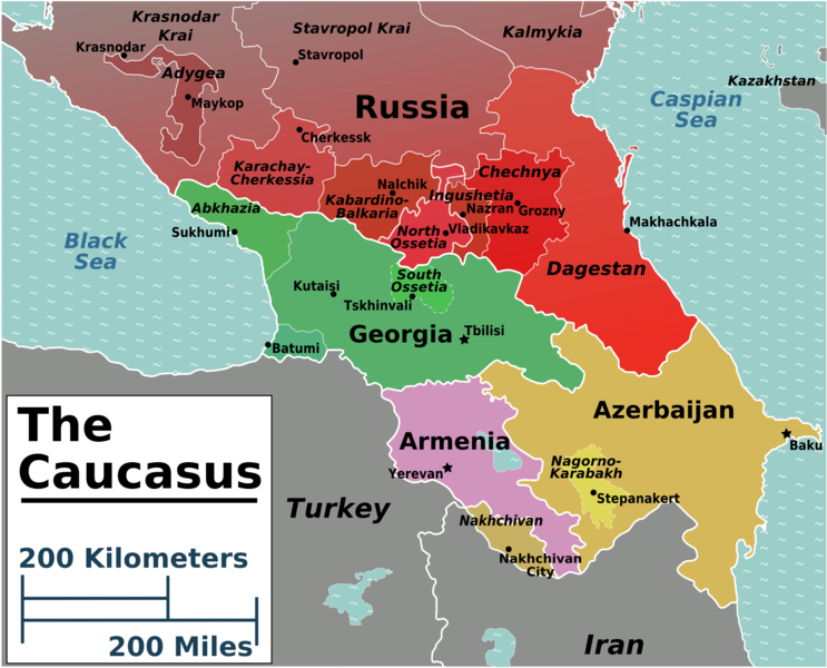
| Description | Caucasus regions map for use on Wikivoyage, English version |
| Date | |
| Source | Own work based on the map of ethno-linguistic groups by Pmx |
| Author | Peter Fitzgerald |
| Other versions |
.png)
.png)

|
This file has been superseded by Caucasus regions map2.png. It is recommended to use the other file. Please note that deleting superseded images requires consent.
|

|

|
This locator map image could be re-created using vector graphics as an SVG file. This has several advantages; see Commons:Media for cleanup for more information. If an SVG form of this image is available, please upload it and afterwards replace this template with
{{vector version available|new image name}}.
It is recommended to name the SVG file “Caucasus regions map.svg”—then the template Vector version available (or Vva) does not need the new image name parameter. |
Licensing
edit

|
Permission is granted to copy, distribute and/or modify this document under the terms of the GNU Free Documentation License, Version 1.2 or any later version published by the Free Software Foundation; with no Invariant Sections, no Front-Cover Texts, and no Back-Cover Texts. A copy of the license is included in the section entitled GNU Free Documentation License. |
This file is licensed under the Creative Commons Attribution-Share Alike 4.0 International, 3.0 Unported, 2.5 Generic, 2.0 Generic and 1.0 Generic license.
- You are free:
- to share – to copy, distribute and transmit the work
- to remix – to adapt the work
- Under the following conditions:
- attribution – You must give appropriate credit, provide a link to the license, and indicate if changes were made. You may do so in any reasonable manner, but not in any way that suggests the licensor endorses you or your use.
- share alike – If you remix, transform, or build upon the material, you must distribute your contributions under the same or compatible license as the original.
Original upload log
edit
| This file was imported from Wikivoyage WTS. |
The original description page was here. All following user names refer to wts.wikivoyage-old.
- 2008-08-03 06:37 (WT-shared) Peterfitzgerald archive copy at the Wayback Machine 2000×1614 (701425 bytes) {{Imagecredit|credit=Peter Fitzgerald, [[:commons:User:Pmx]]|captureDate=3 August 2008|location=Caucasus|source=[[:Image:Caucasus regions ma (Import from wikitravel.org/shared)
File history
Click on a date/time to view the file as it appeared at that time.
| Date/Time | Thumbnail | Dimensions | User | Comment | |
|---|---|---|---|---|---|
| current | 01:19, 22 January 2013 | | 2,000 × 1,614 (685 KB) | Globe-trotter (talk | contribs) | Reverted to version as of 23:06, 17 November 2012 |
| 09:50, 1 January 2013 |  | 2,070 × 1,789 (587 KB) | Travelpleb (talk | contribs) | Changed style, Lessened emphasis on North Caucasus | |
| 10:43, 30 December 2012 |  | 1,997 × 1,612 (632 KB) | Travelpleb (talk | contribs) | Change color scheme | |
| 22:27, 29 December 2012 |  | 1,997 × 1,612 (637 KB) | Travelpleb (talk | contribs) | Emphasized de facto states. Boundaries from openstreetmap.org. | |
| 21:49, 29 December 2012 |  | 1,997 × 1,612 (637 KB) | Travelpleb (talk | contribs) | Changed colors for greater emphasis of de facto states | |
| 23:06, 17 November 2012 |  | 2,000 × 1,614 (685 KB) | MGA73bot2 (talk | contribs) | {{BotMoveToCommons|wts.oldwikivoyage|year={{subst:CURRENTYEAR}}|month={{subst:CURRENTMONTHNAME}}|day={{subst:CURRENTDAY}}}} == {{int:filedesc}} == {{Information |description=Caucasus regions map. Other versions:<br>Portuguese version: [[:wts::Image:Cau... |
You cannot overwrite this file.
File usage on Commons
There are no pages that use this file.
File usage on other wikis
The following other wikis use this file:
- Usage on fr.wikipedia.org
- Usage on sc.wikipedia.org