File:Caucasus topographic map-He.svg

Size of this PNG preview of this SVG file: 771 × 599 pixels. Other resolutions: 309 × 240 pixels | 618 × 480 pixels | 988 × 768 pixels | 1,280 × 995 pixels | 2,560 × 1,990 pixels | 1,155 × 898 pixels.
Original file (SVG file, nominally 1,155 × 898 pixels, file size: 5.64 MB)
Captions
Captions
Add a one-line explanation of what this file represents
Summary edit
| Description |
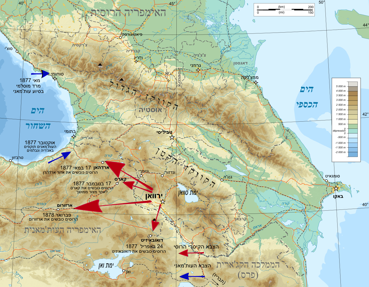
English: Russo-Turkish War (1877–1878) |
| Date | (UTC) |
| Source | |
| Author |
|
| This is a retouched picture, which means that it has been digitally altered from its original version. Modifications: Hebrew. The original can be viewed here: Caucasus topographic map-fr.svg:
|
Licensing edit
I, the copyright holder of this work, hereby publish it under the following licenses:
This file is licensed under the Creative Commons Attribution-Share Alike 3.0 Unported, 2.5 Generic, 2.0 Generic and 1.0 Generic license.
- You are free:
- to share – to copy, distribute and transmit the work
- to remix – to adapt the work
- Under the following conditions:
- attribution – You must give appropriate credit, provide a link to the license, and indicate if changes were made. You may do so in any reasonable manner, but not in any way that suggests the licensor endorses you or your use.
- share alike – If you remix, transform, or build upon the material, you must distribute your contributions under the same or compatible license as the original.

|
Permission is granted to copy, distribute and/or modify this document under the terms of the GNU Free Documentation License, Version 1.2 or any later version published by the Free Software Foundation; with no Invariant Sections, no Front-Cover Texts, and no Back-Cover Texts. A copy of the license is included in the section entitled GNU Free Documentation License. |
You may select the license of your choice.
Original upload log edit
This image is a derivative work of the following images:
- File:Caucasus_topographic_map-fr.svg licensed with Cc-by-sa-3.0,2.5,2.0,1.0, GFDL
- 2008-11-11T15:55:47Z Bourrichon 1155x898 (5773608 Bytes)
- 2008-11-10T18:54:40Z Bourrichon 1155x898 (5774594 Bytes)
- 2008-11-10T18:51:18Z Bourrichon 1155x898 (5774597 Bytes) TYPO
- 2008-11-10T18:38:27Z Bourrichon 1155x898 (5768286 Bytes) +haut-plateau arménien
- 2008-11-10T18:18:15Z Bourrichon 1155x898 (5767383 Bytes) + villes d'Anatolie
- 2008-11-10T16:13:42Z Bourrichon 1155x898 (5761228 Bytes) + chaînes de montagnes
- 2008-11-09T17:14:25Z Bourrichon 1155x898 (5671629 Bytes)
- 2008-11-08T15:27:01Z Bourrichon 1155x898 (5670657 Bytes) == Summary == {{Information |Description={{de|Topographische Karte von [[:de:Kaukasien|Kaukasien]], französische Version}}{{en|Topographic map in French of [[:en:Caucasus|Caucasus]]}}{{fr|Carte topographique en français du
Uploaded with derivativeFX
File history
Click on a date/time to view the file as it appeared at that time.
| Date/Time | Thumbnail | Dimensions | User | Comment | |
|---|---|---|---|---|---|
| current | 01:03, 20 January 2020 | | 1,155 × 898 (5.64 MB) | Takhirgeran Umar (talk | contribs) | clarification |
| 10:38, 16 December 2011 |  | 1,155 × 898 (5.64 MB) | Itzuvit (talk | contribs) | Text | |
| 17:49, 14 December 2011 |  | 1,155 × 898 (5.64 MB) | Itzuvit (talk | contribs) | Lines | |
| 00:30, 11 December 2011 |  | 1,155 × 898 (5.81 MB) | Itzuvit (talk | contribs) | == {{int:filedesc}} == {{Information |Description={{de|Topographische Karte von Kaukasien, französische Version}}{{en|Topographic map in French of Caucasus}}{{fr|Carte topographique en français du [[:fr:Caucase|Caucase |
You cannot overwrite this file.
File usage on Commons
The following 4 pages use this file:
File usage on other wikis
The following other wikis use this file:
- Usage on he.wikipedia.org