File:Cave 1 of Elephanta caves.jpg
Size of this preview: 800 × 599 pixels. Other resolutions: 320 × 239 pixels | 640 × 479 pixels | 1,024 × 766 pixels | 1,280 × 958 pixels | 2,560 × 1,916 pixels | 4,640 × 3,472 pixels.
Original file (4,640 × 3,472 pixels, file size: 8.44 MB, MIME type: image/jpeg)
Captions
Captions
Add a one-line explanation of what this file represents
Summary
edit
| Description |
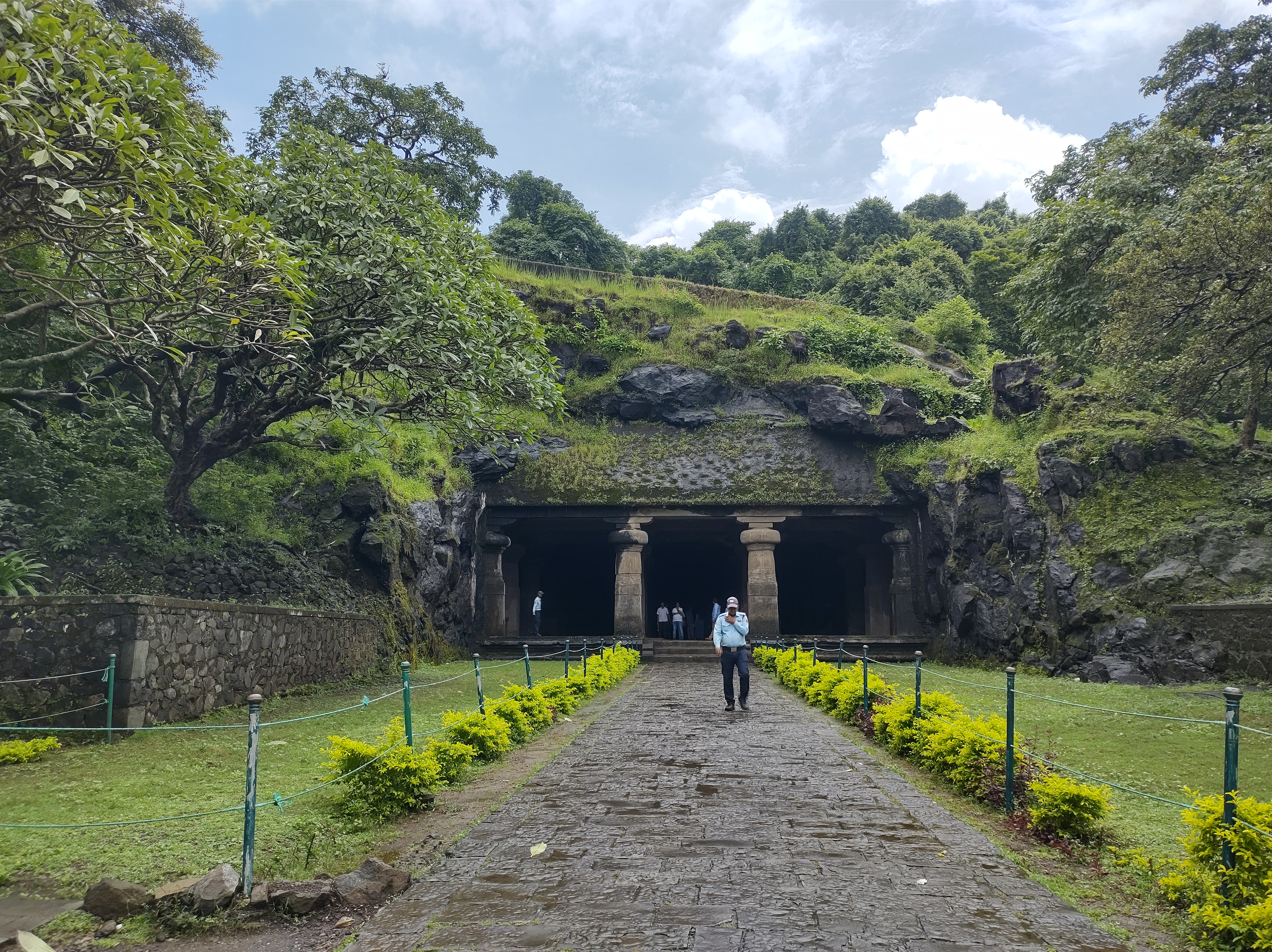
English: The main cave, also called Cave 1, Grand Cave or the Great Cave, is 39.63 metres (130.0 ft) square in plan with a hall (mandapa)and is one of the rock cut caves of the Elephanta complex which is comprises of 7 caves and it is situated in the western hill of Elephanta Island. The Cave has several entrances, the main entrance is unassumingly small and hides the grand hall inside. The main entrance faces north.The cave's main entrance is aligned with the north–south axis.
At the main entrance are four pillars, with three open porticoes and an aisle at the back. Pillars, six in each row, divide the hall into a series of smaller chambers. The roof of the hall has concealed beams supported by stone columns joined together by capitals. This site is declared by the archaeological survey of India as a monument of National Importance Vides No. 2704-A, Dates 26.05.1909 and thereafter inscribed by the UNESCO as a World Heritage site in 1987.मराठी: मुख्य गुहा, ज्याला गुहा 1, ग्रँड केव्ह किंवा ग्रेट केव्ह देखील म्हणतात, 39.63 मीटर (130.0 फूट) चौरस आहे ज्यामध्ये हॉल (मंडप) आहे आणि एलिफंटा संकुलातील खडक कोरलेल्या लेण्यांपैकी एक आहे ज्यात 7 गुंफा आहेत आणि ती एलिफंटा बेटाच्या पश्चिमेकडील टेकडीवर वसलेली आहे. या गुहेला अनेक प्रवेशद्वार आहेत, मुख्य प्रवेशद्वार निःसंशयपणे लहान आहे आणि आतील भव्य सभागृह लपवते.मुख्य प्रवेशद्वार उत्तरेकडे आहे. गुहेचे मुख्य प्रवेशद्वार उत्तर-दक्षिण अक्षाशी संरेखित आहे.मुख्य प्रवेशद्वारावर चार खांब आहेत, ज्यात तीन उघडे द्वारमंडप आणि मागच्या बाजूला एक गल्ली आहे. प्रत्येक रांगेत सहा असलेले खांब सभागृहाला लहान कक्षेच्या मालिकेत विभाजित करतात. सभामंडपाच्या छतावर दगडी स्तंभांनी आधारलेल्या तुळया लपवलेल्या आहेत.
हे स्थळ भारतीय पुरातत्व सर्वेक्षणाद्वारे राष्ट्रीय महत्वाचे स्मारक अधिसूचना क्रमांक 2704-A, दिनांक 26.05.1909 नुसार घोषित केले आहे आणि त्यानंतर 1987 मध्ये UNESCO द्वारे जागतिक वारसा स्थळ म्हणून नोंदवले आहे.
|
||||||
| Date | |||||||
| Source | Own work | ||||||
| Author | Saankav |
Licensing
edit
I, the copyright holder of this work, hereby publish it under the following license:
This file is licensed under the Creative Commons Attribution-Share Alike 4.0 International license.
- You are free:
- to share – to copy, distribute and transmit the work
- to remix – to adapt the work
- Under the following conditions:
- attribution – You must give appropriate credit, provide a link to the license, and indicate if changes were made. You may do so in any reasonable manner, but not in any way that suggests the licensor endorses you or your use.
- share alike – If you remix, transform, or build upon the material, you must distribute your contributions under the same or compatible license as the original.

|
This image was uploaded as part of Wiki Loves Monuments 2022.
|
 |
File history
Click on a date/time to view the file as it appeared at that time.
| Date/Time | Thumbnail | Dimensions | User | Comment | |
|---|---|---|---|---|---|
| current | 16:17, 23 September 2022 | | 4,640 × 3,472 (8.44 MB) | Saankav (talk | contribs) | Uploaded own work with UploadWizard |
You cannot overwrite this file.
File usage on Commons
There are no pages that use this file.