File:Cedar Creek 2007 Oak With County Line Wiki Version.jpg

Size of this preview: 605 × 599 pixels. Other resolutions: 242 × 240 pixels | 485 × 480 pixels | 775 × 768 pixels | 1,034 × 1,024 pixels | 1,769 × 1,752 pixels.
Original file (1,769 × 1,752 pixels, file size: 1.08 MB, MIME type: image/jpeg)
Captions
Captions
Add a one-line explanation of what this file represents
Summary edit
| Description |
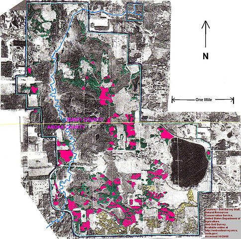
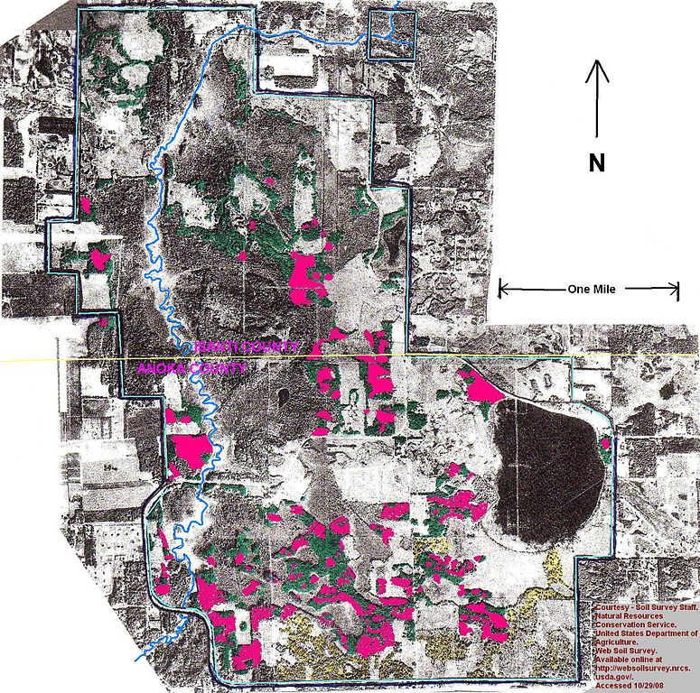
English: Map shows red colored areas being oak wilt infected or killed; 500 of 1,100 acres of upland oak forest dead or dying of oak wilt disease. At University of Minnesota's Cedar Creek Ecosystem Science Reserve. One of the 3 largest oak wilt disease "Reservoirs" in Minnesota. Oak wilt disease delineation based on DNR 2007 color infrared photos and NRCS soils maps. This version shows the Isanti - Anoka county line. |
| Date | |
| Source | Own work |
| Author | Firry Floyd |
Licensing edit
I, the copyright holder of this work, hereby publish it under the following license:
This file is licensed under the Creative Commons Attribution-Share Alike 3.0 Unported license.
- You are free:
- to share – to copy, distribute and transmit the work
- to remix – to adapt the work
- Under the following conditions:
- attribution – You must give appropriate credit, provide a link to the license, and indicate if changes were made. You may do so in any reasonable manner, but not in any way that suggests the licensor endorses you or your use.
- share alike – If you remix, transform, or build upon the material, you must distribute your contributions under the same or compatible license as the original.
File history
Click on a date/time to view the file as it appeared at that time.
| Date/Time | Thumbnail | Dimensions | User | Comment | |
|---|---|---|---|---|---|
| current | 15:05, 19 October 2013 | | 1,769 × 1,752 (1.08 MB) | Firry Floyd (talk | contribs) | User created page with UploadWizard |
You cannot overwrite this file.
File usage on Commons
There are no pages that use this file.