File:CentralAfricanRepublic2017.svg

Size of this PNG preview of this SVG file: 800 × 552 pixels. Other resolutions: 320 × 221 pixels | 640 × 442 pixels | 1,024 × 707 pixels | 1,280 × 884 pixels | 2,560 × 1,768 pixels | 1,606 × 1,109 pixels.
Original file (SVG file, nominally 1,606 × 1,109 pixels, file size: 913 KB)
Captions
Captions
Add a one-line explanation of what this file represents
W3C-validity not checked.
Summary
edit
| Description |
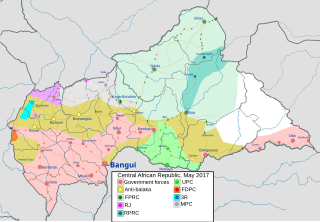
English: Map of control in the Central African Republic in 2017. Based on:
|
| Date | |
| Source | Own work |
| Author | Borysk5 |
Licensing
edit
I, the copyright holder of this work, hereby publish it under the following license:
This file is licensed under the Creative Commons Attribution-Share Alike 4.0 International license.
- You are free:
- to share – to copy, distribute and transmit the work
- to remix – to adapt the work
- Under the following conditions:
- attribution – You must give appropriate credit, provide a link to the license, and indicate if changes were made. You may do so in any reasonable manner, but not in any way that suggests the licensor endorses you or your use.
- share alike – If you remix, transform, or build upon the material, you must distribute your contributions under the same or compatible license as the original.
File history
Click on a date/time to view the file as it appeared at that time.
| Date/Time | Thumbnail | Dimensions | User | Comment | |
|---|---|---|---|---|---|
| current | 12:31, 15 April 2021 | | 1,606 × 1,109 (913 KB) | Borysk5 (talk | contribs) | Correction: After analyizng document https://pure.diis.dk/ws/files/1261246/1711_CAR_roadblocks_English.pdf it |
| 11:25, 2 March 2021 |  | 1,606 × 1,109 (913 KB) | Borysk5 (talk | contribs) | {{Information |description ={{en|1=Map of control in the Central African Republic in 2017. Based on: * [https://ipisresearch.be/mapping/webmapping/car/v2/#5.5/22/5.5/4/2/ IPIS] * en:Timeline_of_the_Central_African_Republic_Civil_War }} |date =2021-03-02 |source ={{Own}} |author =Borysk5 }} |
You cannot overwrite this file.
File usage on Commons
There are no pages that use this file.
File usage on other wikis
The following other wikis use this file:
- Usage on en.wikipedia.org
- Usage on zh.wikipedia.org